
WW 126 SEVERE TSTM AR OK 182035Z – 190400Z
URGENT – IMMEDIATE BROADCAST REQUESTED
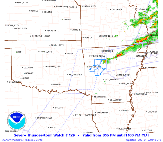
Severe Thunderstorm Watch Number 126
NWS Storm Prediction Center Norman OK
335 PM CDT Thu Apr 18 2024
The NWS Storm Prediction Center has issued a
* Severe Thunderstorm Watch for portions of
Western Arkansas
Eastern Oklahoma
* Effective this Thursday afternoon and evening from 335 PM until
1100 PM CDT.
* Primary threats include…
Scattered large hail and isolated very large hail events to 2
inches in diameter likely
Scattered damaging wind gusts to 70 mph likely
SUMMARY…Thunderstorms coverage and intensity is expected to
increase along a cold front currently moving southeastward across
eastern Oklahoma. Robust buoyancy and strong vertical shear will
support supercells capable of hail up to 2″ in diameter and damaging
gusts from 45 to 65 mph.
The severe thunderstorm watch area is approximately along and 55
statute miles east and west of a line from 25 miles west southwest
of De Queen AR to 30 miles north northeast of Fayetteville AR. For a
complete depiction of the watch see the associated watch outline
update (WOUS64 KWNS WOU6).
PRECAUTIONARY/PREPAREDNESS ACTIONS…
REMEMBER…A Severe Thunderstorm Watch means conditions are
favorable for severe thunderstorms in and close to the watch area.
Persons in these areas should be on the lookout for threatening
weather conditions and listen for later statements and possible
warnings. Severe thunderstorms can and occasionally do produce
tornadoes.
&&
OTHER WATCH INFORMATION…CONTINUE…WW 125…
AVIATION…A few severe thunderstorms with hail surface and aloft to
2 inches. Extreme turbulence and surface wind gusts to 60 knots. A
few cumulonimbi with maximum tops to 500. Mean storm motion vector
27035.
…Mosier