
WW 129 SEVERE TSTM IL IN KY MO 182335Z – 190700Z
URGENT – IMMEDIATE BROADCAST REQUESTED
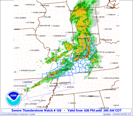
Severe Thunderstorm Watch Number 129
NWS Storm Prediction Center Norman OK
635 PM CDT Thu Apr 18 2024
The NWS Storm Prediction Center has issued a
* Severe Thunderstorm Watch for portions of
Southern Illinois
Southwest Indiana
Western Kentucky
Southeast Missouri
* Effective this Thursday night and Friday morning from 635 PM
until 200 AM CDT.
* Primary threats include…
Scattered damaging wind gusts to 70 mph likely
Isolated large hail events to 1.5 inches in diameter possible
A tornado or two possible
SUMMARY…Severe storms will continue to steadily move eastward
across the region, initially across southern Illinois and southeast
Missouri, reaching southwest Indiana/western Kentucky by mid to late
evening.
The severe thunderstorm watch area is approximately along and 85
statute miles east and west of a line from 35 miles south southwest
of Paducah KY to 5 miles east northeast of Terre Haute IN. For a
complete depiction of the watch see the associated watch outline
update (WOUS64 KWNS WOU9).
PRECAUTIONARY/PREPAREDNESS ACTIONS…
REMEMBER…A Severe Thunderstorm Watch means conditions are
favorable for severe thunderstorms in and close to the watch area.
Persons in these areas should be on the lookout for threatening
weather conditions and listen for later statements and possible
warnings. Severe thunderstorms can and occasionally do produce
tornadoes.
&&
OTHER WATCH INFORMATION…CONTINUE…WW 125…WW 126…WW
127…WW 128…
AVIATION…A few severe thunderstorms with hail surface and aloft to
1.5 inches. Extreme turbulence and surface wind gusts to 60 knots. A
few cumulonimbi with maximum tops to 500. Mean storm motion vector
27035.
…Guyer