
WW 130 SEVERE TSTM AR MO TN 190210Z – 190700Z
URGENT – IMMEDIATE BROADCAST REQUESTED
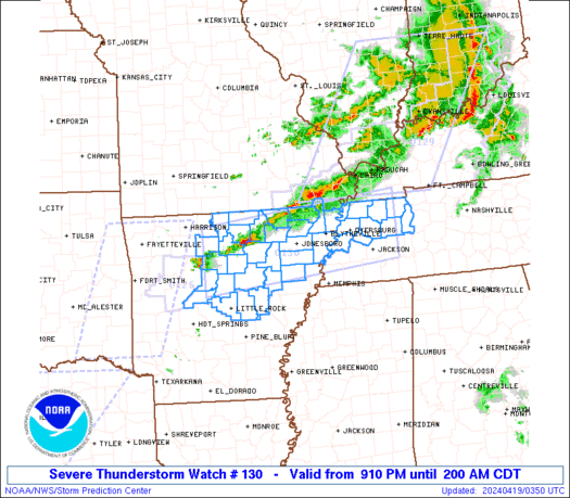
Severe Thunderstorm Watch Number 130
NWS Storm Prediction Center Norman OK
910 PM CDT Thu Apr 18 2024
The NWS Storm Prediction Center has issued a
* Severe Thunderstorm Watch for portions of
Central and Northern Arkansas
Missouri Bootheel
Northwest Tennessee
* Effective this Thursday night and Friday morning from 910 PM
until 200 AM CDT.
* Primary threats include…
Scattered large hail and isolated very large hail events to 2
inches in diameter possible
Scattered damaging wind gusts to 65 mph possible
A tornado or two possible
SUMMARY…Strong to severe thunderstorms are expected to move
generally southeastward across the region, with the strongest storms
capable of mostly a damaging wind and hail risk through the early
overnight.
The severe thunderstorm watch area is approximately along and 45
statute miles north and south of a line from 45 miles south
southwest of Flippin AR to 45 miles northeast of Jackson TN. For a
complete depiction of the watch see the associated watch outline
update (WOUS64 KWNS WOU0).
PRECAUTIONARY/PREPAREDNESS ACTIONS…
REMEMBER…A Severe Thunderstorm Watch means conditions are
favorable for severe thunderstorms in and close to the watch area.
Persons in these areas should be on the lookout for threatening
weather conditions and listen for later statements and possible
warnings. Severe thunderstorms can and occasionally do produce
tornadoes.
&&
OTHER WATCH INFORMATION…CONTINUE…WW 126…WW 128…WW 129…
AVIATION…A few severe thunderstorms with hail surface and aloft to
2 inches. Extreme turbulence and surface wind gusts to 55 knots. A
few cumulonimbi with maximum tops to 500. Mean storm motion vector
30025.
…Guyer