
WW 15 SEVERE TSTM TX 110355Z – 111000Z
URGENT – IMMEDIATE BROADCAST REQUESTED
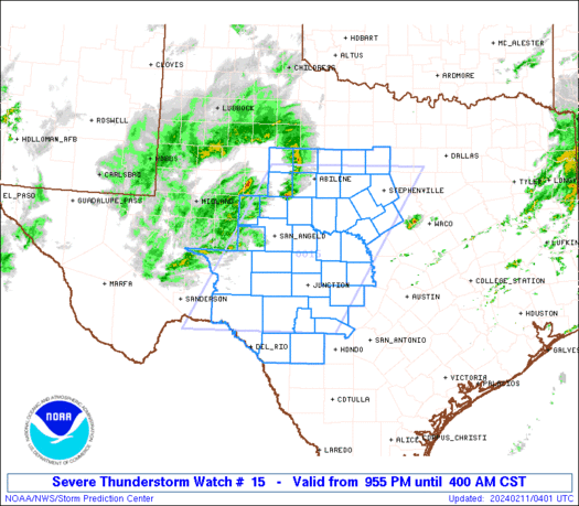
Severe Thunderstorm Watch Number 15
NWS Storm Prediction Center Norman OK
955 PM CST Sat Feb 10 2024
The NWS Storm Prediction Center has issued a
* Severe Thunderstorm Watch for portions of
West-central Texas
* Effective this Saturday night and Sunday morning from 955 PM
until 400 AM CST.
* Primary threats include…
Scattered large hail likely with isolated very large hail events
to 2.5 inches in diameter possible
Isolated damaging wind gusts to 70 mph possible
A tornado or two possible
SUMMARY…Thunderstorms will intensify tonight along a cold front
over west-central Texas. These storms will likely pose a risk of
large hail and isolated damaging wind gusts as they track
east-northeastward across the watch area. A tornado or two cannot
be ruled out in the southern part of the watch.
The severe thunderstorm watch area is approximately along and 95
statute miles east and west of a line from 85 miles southwest of
Junction TX to 45 miles east northeast of Abilene TX. For a complete
depiction of the watch see the associated watch outline update
(WOUS64 KWNS WOU5).
PRECAUTIONARY/PREPAREDNESS ACTIONS…
REMEMBER…A Severe Thunderstorm Watch means conditions are
favorable for severe thunderstorms in and close to the watch area.
Persons in these areas should be on the lookout for threatening
weather conditions and listen for later statements and possible
warnings. Severe thunderstorms can and occasionally do produce
tornadoes.
&&
AVIATION…A few severe thunderstorms with hail surface and aloft to
2.5 inches. Extreme turbulence and surface wind gusts to 60 knots. A
few cumulonimbi with maximum tops to 500. Mean storm motion vector
25035.
…Hart