
WW 174 SEVERE TSTM CO KS NE 020100Z – 020700Z
URGENT – IMMEDIATE BROADCAST REQUESTED
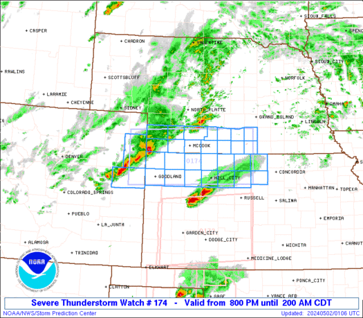
Severe Thunderstorm Watch Number 174
NWS Storm Prediction Center Norman OK
800 PM CDT Wed May 1 2024
The NWS Storm Prediction Center has issued a
* Severe Thunderstorm Watch for portions of
Northeast Colorado
Northwest and North-Central Kansas
Southwest Nebraska
* Effective this Wednesday night and Thursday morning from 800 PM
until 200 AM CDT.
* Primary threats include…
Scattered large hail events to 1.5 inches in diameter possible
Isolated damaging wind gusts to 70 mph possible
A tornado or two possible
SUMMARY…Severe storms are expected to further develop from
northeast Colorado into southwest Nebraska and northwest Kansas,
while additional area of storms could move into north-central
Kansas. Large hail should be the most common severe hazard, but
locally damaging gusts are possible and some tornado risk may exist
across north-central Kansas.
The severe thunderstorm watch area is approximately along and 50
statute miles north and south of a line from 45 miles north
northwest of Burlington CO to 45 miles south of Hastings NE. For a
complete depiction of the watch see the associated watch outline
update (WOUS64 KWNS WOU4).
PRECAUTIONARY/PREPAREDNESS ACTIONS…
REMEMBER…A Severe Thunderstorm Watch means conditions are
favorable for severe thunderstorms in and close to the watch area.
Persons in these areas should be on the lookout for threatening
weather conditions and listen for later statements and possible
warnings. Severe thunderstorms can and occasionally do produce
tornadoes.
&&
OTHER WATCH INFORMATION…CONTINUE…WW 170…WW 171…WW
172…WW 173…
AVIATION…A few severe thunderstorms with hail surface and aloft to
1.5 inches. Extreme turbulence and surface wind gusts to 60 knots. A
few cumulonimbi with maximum tops to 500. Mean storm motion vector
25025.
…Guyer