
WW 175 SEVERE TSTM OK TX 020340Z – 020900Z
URGENT – IMMEDIATE BROADCAST REQUESTED
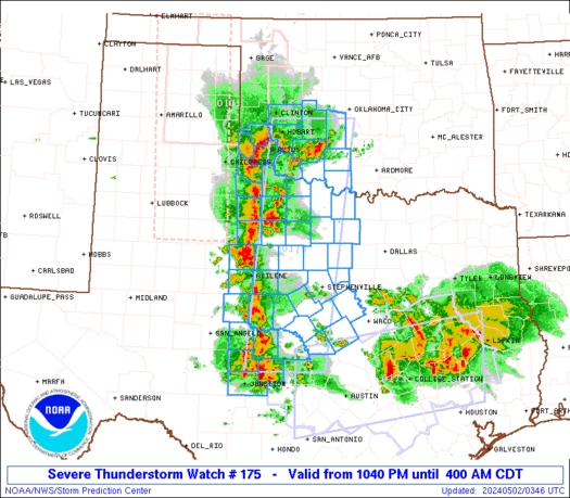
Severe Thunderstorm Watch Number 175
NWS Storm Prediction Center Norman OK
1040 PM CDT Wed May 1 2024
The NWS Storm Prediction Center has issued a
* Severe Thunderstorm Watch for portions of
Southwest Oklahoma
West-central and western North Texas
* Effective this Wednesday night and Thursday morning from 1040
PM until 400 AM CDT.
* Primary threats include…
Scattered damaging wind gusts to 70 mph possible
Scattered large hail events to 1.5 inches in diameter possible
A tornado or two possible
SUMMARY…Scattered strong to severe storms will continue eastward
through the overnight with bouts of large hail and locally damaging
winds as the primary hazards.
The severe thunderstorm watch area is approximately along and 50
statute miles east and west of a line from 25 miles west northwest
of Chickasha OK to 75 miles south of Brownwood TX. For a complete
depiction of the watch see the associated watch outline update
(WOUS64 KWNS WOU5).
PRECAUTIONARY/PREPAREDNESS ACTIONS…
REMEMBER…A Severe Thunderstorm Watch means conditions are
favorable for severe thunderstorms in and close to the watch area.
Persons in these areas should be on the lookout for threatening
weather conditions and listen for later statements and possible
warnings. Severe thunderstorms can and occasionally do produce
tornadoes.
&&
OTHER WATCH INFORMATION…CONTINUE…WW 171…WW 172…WW
173…WW 174…
AVIATION…A few severe thunderstorms with hail surface and aloft to
1.5 inches. Extreme turbulence and surface wind gusts to 60 knots. A
few cumulonimbi with maximum tops to 500. Mean storm motion vector
25025.
…Guyer