
WW 176 SEVERE TSTM KS NE 020445Z – 021100Z
URGENT – IMMEDIATE BROADCAST REQUESTED
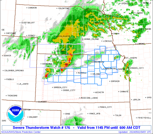
Severe Thunderstorm Watch Number 176
NWS Storm Prediction Center Norman OK
1145 PM CDT Wed May 1 2024
The NWS Storm Prediction Center has issued a
* Severe Thunderstorm Watch for portions of
West-Central and Northeast Kansas
Southeast Nebraska
* Effective this Wednesday night and Thursday morning from 1145
PM until 600 AM CDT.
* Primary threats include…
Scattered damaging winds likely with isolated significant gusts
to 80 mph possible
Isolated large hail events to 1.5 inches in diameter possible
A tornado or two possible
SUMMARY…A well-organized bowing squall line will likely continue
east-northeastward toward northeast Kansas and far southeast
Nebraska, while other storms develop across additional portions of
western and central Kansas.
The severe thunderstorm watch area is approximately along and 55
statute miles north and south of a line from 90 miles west southwest
of Hill City KS to 25 miles south of Falls City NE. For a complete
depiction of the watch see the associated watch outline update
(WOUS64 KWNS WOU6).
PRECAUTIONARY/PREPAREDNESS ACTIONS…
REMEMBER…A Severe Thunderstorm Watch means conditions are
favorable for severe thunderstorms in and close to the watch area.
Persons in these areas should be on the lookout for threatening
weather conditions and listen for later statements and possible
warnings. Severe thunderstorms can and occasionally do produce
tornadoes.
&&
OTHER WATCH INFORMATION…CONTINUE…WW 172…WW 173…WW
174…WW 175…
AVIATION…A few severe thunderstorms with hail surface and aloft to
1.5 inches. Extreme turbulence and surface wind gusts to 70 knots. A
few cumulonimbi with maximum tops to 550. Mean storm motion vector
25040.
…Guyer