
WW 229 SEVERE TSTM FL GA CW 100805Z – 101500Z
URGENT – IMMEDIATE BROADCAST REQUESTED
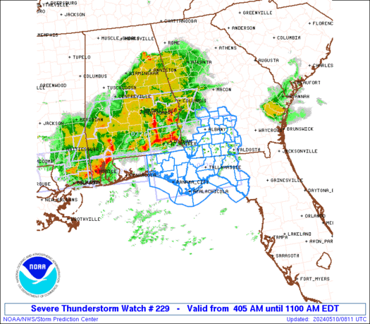
Severe Thunderstorm Watch Number 229
NWS Storm Prediction Center Norman OK
405 AM EDT Fri May 10 2024
The NWS Storm Prediction Center has issued a
* Severe Thunderstorm Watch for portions of
Northern Florida
Southern Georgia
Coastal Waters
* Effective this Friday morning from 405 AM until 1100 AM EDT.
* Primary threats include…
Widespread damaging winds likely with isolated significant gusts
to 80 mph possible
Isolated large hail events to 1.5 inches in diameter possible
A tornado or two possible
SUMMARY…Multiple well-organized squall lines with bowing segments
will quickly spread east-southeastward across the region through the
early morning hours, with damaging winds being the primary hazard.
The severe thunderstorm watch area is approximately along and 75
statute miles north and south of a line from 45 miles northwest of
Panama City FL to 5 miles east of Valdosta GA. For a complete
depiction of the watch see the associated watch outline update
(WOUS64 KWNS WOU9).
PRECAUTIONARY/PREPAREDNESS ACTIONS…
REMEMBER…A Severe Thunderstorm Watch means conditions are
favorable for severe thunderstorms in and close to the watch area.
Persons in these areas should be on the lookout for threatening
weather conditions and listen for later statements and possible
warnings. Severe thunderstorms can and occasionally do produce
tornadoes.
&&
OTHER WATCH INFORMATION…CONTINUE…WW 226…WW 227…WW 228…
AVIATION…A few severe thunderstorms with hail surface and aloft to
1.5 inches. Extreme turbulence and surface wind gusts to 70 knots. A
few cumulonimbi with maximum tops to 550. Mean storm motion vector
29045.
…Guyer