
WW 239 SEVERE TSTM LA MS CW 132225Z – 140500Z
URGENT – IMMEDIATE BROADCAST REQUESTED
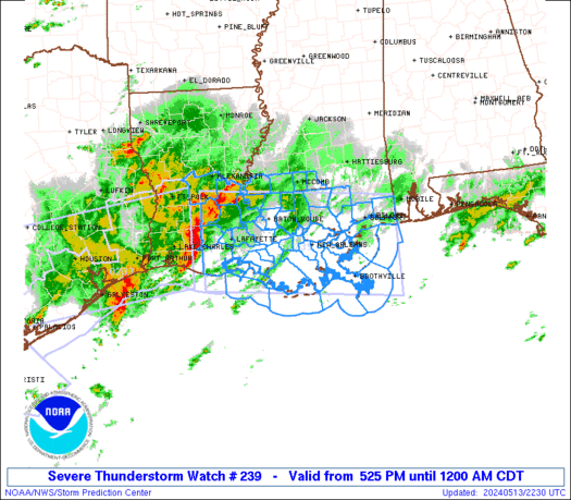
Severe Thunderstorm Watch Number 239
NWS Storm Prediction Center Norman OK
525 PM CDT Mon May 13 2024
The NWS Storm Prediction Center has issued a
* Severe Thunderstorm Watch for portions of
Central and Southeast Louisiana
Southern Mississippi
Coastal Waters
* Effective this Monday afternoon from 525 PM until Midnight CDT.
* Primary threats include…
Scattered damaging winds and isolated significant gusts to 75
mph likely
Scattered large hail and isolated very large hail events to 2
inches in diameter possible
A tornado or two possible
SUMMARY…A fast moving line of thunderstorms over southwest
Louisiana will track across the watch area during the evening.
Damaging winds are the main threat with these storms, along with a
possible tornado or two along the leading edge of activity.
The severe thunderstorm watch area is approximately along and 65
statute miles north and south of a line from 40 miles northwest of
Intracoastal City LA to 55 miles southeast of Gulfport MS. For a
complete depiction of the watch see the associated watch outline
update (WOUS64 KWNS WOU9).
PRECAUTIONARY/PREPAREDNESS ACTIONS…
REMEMBER…A Severe Thunderstorm Watch means conditions are
favorable for severe thunderstorms in and close to the watch area.
Persons in these areas should be on the lookout for threatening
weather conditions and listen for later statements and possible
warnings. Severe thunderstorms can and occasionally do produce
tornadoes.
&&
OTHER WATCH INFORMATION…CONTINUE…WW 236…WW 237…WW 238…
AVIATION…A few severe thunderstorms with hail surface and aloft to
2 inches. Extreme turbulence and surface wind gusts to 65 knots. A
few cumulonimbi with maximum tops to 500. Mean storm motion vector
27035.
…Hart