
WW 394 SEVERE TSTM DC DE MD NJ PA VA CW 061820Z – 070100Z
URGENT – IMMEDIATE BROADCAST REQUESTED
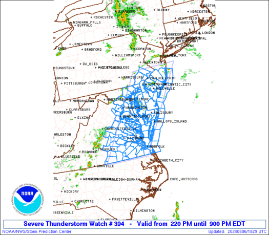
Severe Thunderstorm Watch Number 394
NWS Storm Prediction Center Norman OK
220 PM EDT Thu Jun 6 2024
The NWS Storm Prediction Center has issued a
* Severe Thunderstorm Watch for portions of
District Of Columbia
Delaware
Central and Eastern Maryland
Southern half of New Jersey
Southeast Pennsylvania
Eastern and Southern Virginia
Coastal Waters
* Effective this Thursday afternoon and evening from 220 PM until
900 PM EDT.
* Primary threats include…
Scattered damaging wind gusts to 65 mph possible
SUMMARY…Scattered thunderstorms will likely continue to develop
through the afternoon into several broken bands of strong to severe
thunderstorms. The stronger thunderstorms will be capable of strong
to severe gusts (50-65 mph) capable of wind damage. This activity
will likely push east of the Atlantic Seaboard by mid to late
evening with the severe risk diminishing from west to east across
the Watch area.
The severe thunderstorm watch area is approximately along and 65
statute miles east and west of a line from 5 miles northeast of
Trenton NJ to 35 miles east southeast of South Hill VA. For a
complete depiction of the watch see the associated watch outline
update (WOUS64 KWNS WOU4).
PRECAUTIONARY/PREPAREDNESS ACTIONS…
REMEMBER…A Severe Thunderstorm Watch means conditions are
favorable for severe thunderstorms in and close to the watch area.
Persons in these areas should be on the lookout for threatening
weather conditions and listen for later statements and possible
warnings. Severe thunderstorms can and occasionally do produce
tornadoes.
&&
AVIATION…A few severe thunderstorms with hail surface and aloft to
1 inch. Extreme turbulence and surface wind gusts to 55 knots. A few
cumulonimbi with maximum tops to 400. Mean storm motion vector
27025.
…Smith