
WW 400 SEVERE TSTM KS 090050Z – 090800Z
URGENT – IMMEDIATE BROADCAST REQUESTED
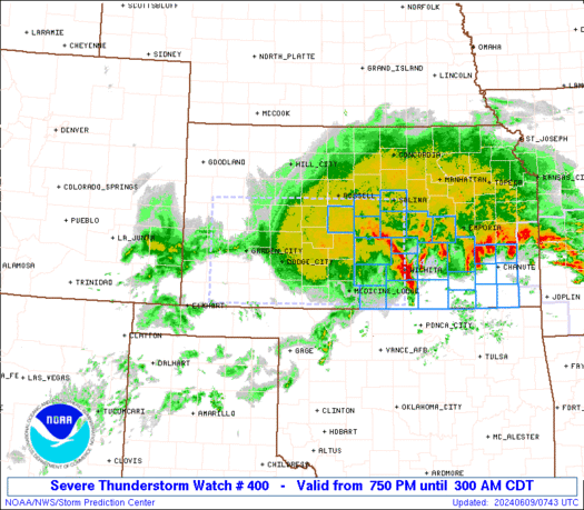
Severe Thunderstorm Watch Number 400
NWS Storm Prediction Center Norman OK
750 PM CDT Sat Jun 8 2024
The NWS Storm Prediction Center has issued a
* Severe Thunderstorm Watch for portions of
Western and Central Kansas
* Effective this Saturday night and Sunday morning from 750 PM
until 300 AM CDT.
* Primary threats include…
Scattered damaging winds and isolated significant gusts to 80
mph likely
Scattered large hail and isolated very large hail events to 2.5
inches in diameter possible
A tornado or two possible
SUMMARY…Severe thunderstorms will move east across the watch area
this evening and overnight, with a risk for significant damaging
wind gusts up to 80 mph and very large hail. A tornado or two will
also be possible.
The severe thunderstorm watch area is approximately along and 60
statute miles either side of a line from 40 miles west of Garden
City KS to 20 miles north of Wichita KS. For a complete depiction of
the watch see the associated watch outline update (WOUS64 KWNS
WOU0).
PRECAUTIONARY/PREPAREDNESS ACTIONS…
REMEMBER…A Severe Thunderstorm Watch means conditions are
favorable for severe thunderstorms in and close to the watch area.
Persons in these areas should be on the lookout for threatening
weather conditions and listen for later statements and possible
warnings. Severe thunderstorms can and occasionally do produce
tornadoes.
&&
OTHER WATCH INFORMATION…CONTINUE…WW 398…WW 399…
AVIATION…A few severe thunderstorms with hail surface and aloft to
2.5 inches. Extreme turbulence and surface wind gusts to 70 knots. A
few cumulonimbi with maximum tops to 550. Mean storm motion vector
29035.
…Bunting