
WW 458 SEVERE TSTM NE SD 252155Z – 260400Z
URGENT – IMMEDIATE BROADCAST REQUESTED
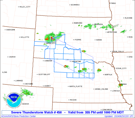
Severe Thunderstorm Watch Number 458
NWS Storm Prediction Center Norman OK
355 PM MDT Tue Jun 25 2024
The NWS Storm Prediction Center has issued a
* Severe Thunderstorm Watch for portions of
Northern Nebraska
Southwest and south-central South Dakota
* Effective this Tuesday afternoon and evening from 355 PM until
1000 PM MDT.
* Primary threats include…
Scattered damaging winds and isolated significant gusts to 75
mph possible
Scattered large hail and isolated very large hail events to 2.5
inches in diameter possible
A tornado or two possible
SUMMARY…Supercells should continue to pose a threat for large hail
around 1.5-2.5 inches in diameter, along with severe/damaging winds
of 60-75 mph, as they move east-southeastward this afternoon and
evening.
The severe thunderstorm watch area is approximately along and 55
statute miles north and south of a line from 50 miles west southwest
of Philip SD to 15 miles east southeast of Oneill NE. For a complete
depiction of the watch see the associated watch outline update
(WOUS64 KWNS WOU8).
PRECAUTIONARY/PREPAREDNESS ACTIONS…
REMEMBER…A Severe Thunderstorm Watch means conditions are
favorable for severe thunderstorms in and close to the watch area.
Persons in these areas should be on the lookout for threatening
weather conditions and listen for later statements and possible
warnings. Severe thunderstorms can and occasionally do produce
tornadoes.
&&
OTHER WATCH INFORMATION…CONTINUE…WW 457…
AVIATION…A few severe thunderstorms with hail surface and aloft to
2.5 inches. Extreme turbulence and surface wind gusts to 65 knots. A
few cumulonimbi with maximum tops to 550. Mean storm motion vector
30035.
…Gleason