
WW 56 SEVERE TSTM TX CW 170335Z – 171100Z
URGENT – IMMEDIATE BROADCAST REQUESTED
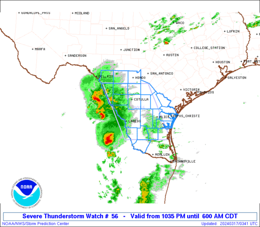
Severe Thunderstorm Watch Number 56
NWS Storm Prediction Center Norman OK
1035 PM CDT Sat Mar 16 2024
The NWS Storm Prediction Center has issued a
* Severe Thunderstorm Watch for portions of
southern Texas
Coastal Waters
* Effective this Saturday night and Sunday morning from 1035 PM
until 600 AM CDT.
* Primary threats include…
Scattered large hail and isolated very large hail events to 2
inches in diameter possible
Isolated damaging wind gusts to 70 mph possible
SUMMARY…Thunderstorms west of the Rio Grande will spread eastward
into southern portions of Texas over the next couple of hours.
Large hail will be the primary threat with these storms, though a
few locally severe/damaging wind gusts will also be possible —
particularly across the more southern portions of the WW.
The severe thunderstorm watch area is approximately along and 65
statute miles east and west of a line from 50 miles north northwest
of Cotulla TX to 70 miles south southwest of Alice TX. For a
complete depiction of the watch see the associated watch outline
update (WOUS64 KWNS WOU6).
PRECAUTIONARY/PREPAREDNESS ACTIONS…
REMEMBER…A Severe Thunderstorm Watch means conditions are
favorable for severe thunderstorms in and close to the watch area.
Persons in these areas should be on the lookout for threatening
weather conditions and listen for later statements and possible
warnings. Severe thunderstorms can and occasionally do produce
tornadoes.
&&
AVIATION…A few severe thunderstorms with hail surface and aloft to
2 inches. Extreme turbulence and surface wind gusts to 60 knots. A
few cumulonimbi with maximum tops to 500. Mean storm motion vector
26030.
…Goss