
WW 171 TORNADO OK TX 012025Z – 020400Z
URGENT – IMMEDIATE BROADCAST REQUESTED
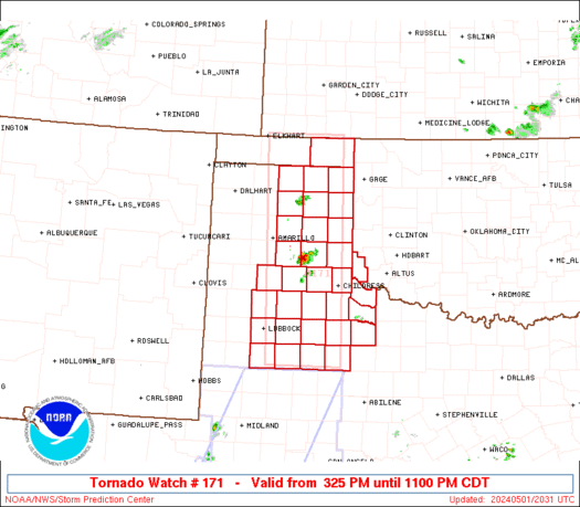
Tornado Watch Number 171
NWS Storm Prediction Center Norman OK
325 PM CDT Wed May 1 2024
The NWS Storm Prediction Center has issued a
* Tornado Watch for portions of
Southwest Oklahoma
Eastern Texas Panhandle
* Effective this Wednesday afternoon and evening from 325 PM
until 1100 PM CDT.
* Primary threats include…
A few tornadoes possible
Widespread large hail and isolated very large hail events to 4
inches in diameter likely
Scattered damaging winds and isolated significant gusts to 75
mph likely
SUMMARY…Widely scattered but intense thunderstorms are expected to
affect the watch area through the afternoon and evening. Very large
hail, damaging wind gusts, and a few tornadoes will be possible with
these storms.
The tornado watch area is approximately along and 45 statute miles
east and west of a line from 5 miles west northwest of Liberal KS to
105 miles south southwest of Childress TX. For a complete depiction
of the watch see the associated watch outline update (WOUS64 KWNS
WOU1).
PRECAUTIONARY/PREPAREDNESS ACTIONS…
REMEMBER…A Tornado Watch means conditions are favorable for
tornadoes and severe thunderstorms in and close to the watch
area. Persons in these areas should be on the lookout for
threatening weather conditions and listen for later statements
and possible warnings.
&&
OTHER WATCH INFORMATION…CONTINUE…WW 170…
AVIATION…Tornadoes and a few severe thunderstorms with hail
surface and aloft to 4 inches. Extreme turbulence and surface wind
gusts to 65 knots. A few cumulonimbi with maximum tops to 500. Mean
storm motion vector 24035.
…Hart