
WW 21 TORNADO LA MS CW 041820Z – 050100Z
URGENT - IMMEDIATE BROADCAST REQUESTED
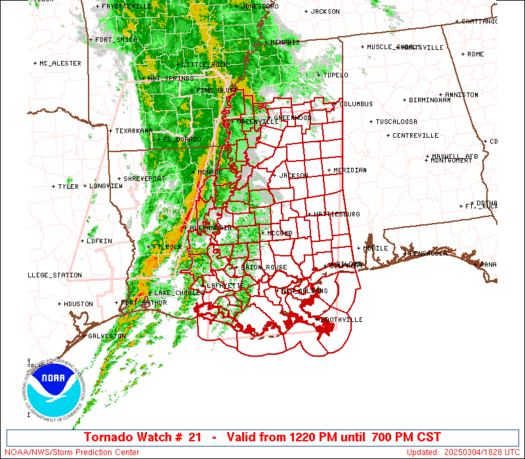
Tornado Watch Number 21
NWS Storm Prediction Center Norman OK
1220 PM CST Tue Mar 4 2025
The NWS Storm Prediction Center has issued a
* Tornado Watch for portions of
Eastern and Southeastern Louisiana
Central and Southern Mississippi
Coastal Waters
* Effective this Tuesday afternoon and evening from 1220 PM until
700 PM CST.
* Primary threats include...
A few tornadoes likely with a couple intense tornadoes possible
Scattered damaging winds and isolated significant gusts to 80
mph likely
Isolated large hail events to 1 inch in diameter possible
SUMMARY...A line of strong to severe thunderstorms continues to push
eastward towards eastern/southern LA along a progressive cold front.
The environment ahead of this front across eastern/southern LA and
into much of central and southern MS will become increasingly
favorable for continued severe thunderstorms over the next several
hours. Tornadoes are the primary severe hazard, with a few strong
(i.e. EF2+) tornadoes possible. Strong to potentially significant
(i.e. over 74 mph) wind gusts are possible within this line as well.
The tornado watch area is approximately along and 90 statute miles
east and west of a line from 15 miles east northeast of Greenwood MS
to 35 miles south southeast of Houma LA. For a complete depiction of
the watch see the associated watch outline update (WOUS64 KWNS
WOU1).
PRECAUTIONARY/PREPAREDNESS ACTIONS...
REMEMBER...A Tornado Watch means conditions are favorable for
tornadoes and severe thunderstorms in and close to the watch
area. Persons in these areas should be on the lookout for
threatening weather conditions and listen for later statements
and possible warnings.
&&
OTHER WATCH INFORMATION...CONTINUE...WW 20...
AVIATION...Tornadoes and a few severe thunderstorms with hail
surface and aloft to 1 inch. Extreme turbulence and surface wind
gusts to 70 knots. A few cumulonimbi with maximum tops to 500. Mean
storm motion vector 24035.
...Mosier