
WW 281 TORNADO WI LM 212340Z – 220500Z
URGENT – IMMEDIATE BROADCAST REQUESTED
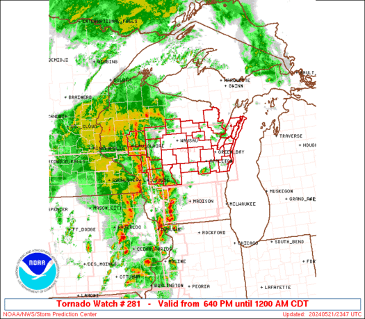
Tornado Watch Number 281
NWS Storm Prediction Center Norman OK
640 PM CDT Tue May 21 2024
The NWS Storm Prediction Center has issued a
* Tornado Watch for portions of
Central and northeast Wisconsin
Lake Michigan
* Effective this Tuesday night from 640 PM until Midnight CDT.
* Primary threats include…
A few tornadoes likely with a couple intense tornadoes possible
Widespread damaging winds and isolated significant gusts to 80
mph likely
Scattered large hail events to 1 inch in diameter possible
SUMMARY…Initial supercells will consolidate into a more solid
squall line that will move rapidly northeastward across Wisconsin
through early tonight. Embedded circulations will be capable of
producing tornadoes (a couple of which could produce roughly EF2
damage), damaging gusts up to 80 mph, and isolated large hail near 1
inch in diameter for the next several hours.
The tornado watch area is approximately along and 85 statute miles
east and west of a line from 35 miles northeast of Wausau WI to 35
miles southwest of Oshkosh WI. For a complete depiction of the watch
see the associated watch outline update (WOUS64 KWNS WOU1).
PRECAUTIONARY/PREPAREDNESS ACTIONS…
REMEMBER…A Tornado Watch means conditions are favorable for
tornadoes and severe thunderstorms in and close to the watch
area. Persons in these areas should be on the lookout for
threatening weather conditions and listen for later statements
and possible warnings.
&&
OTHER WATCH INFORMATION…CONTINUE…WW 277…WW 278…WW
279…WW 280…
AVIATION…Tornadoes and a few severe thunderstorms with hail
surface and aloft to 1 inch. Extreme turbulence and surface wind
gusts to 70 knots. A few cumulonimbi with maximum tops to 500. Mean
storm motion vector 24050.
…Thompson