
WW 6 TORNADO AL LA MS CW 121930Z – 130400Z
URGENT - IMMEDIATE BROADCAST REQUESTED
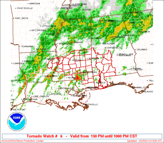
Tornado Watch Number 6
NWS Storm Prediction Center Norman OK
130 PM CST Wed Feb 12 2025
The NWS Storm Prediction Center has issued a
* Tornado Watch for portions of
Southwest Alabama
Eastern Louisiana
Southern and South-Central Mississippi
Coastal Waters
* Effective this Wednesday afternoon and evening from 130 PM
until 1000 PM CST.
* Primary threats include...
A few tornadoes and a couple intense tornadoes likely
Scattered damaging winds likely with isolated significant gusts
to 75 mph possible
SUMMARY...Conditions favorable for rotating storms capable of
tornadoes and damaging winds will increasingly expand
north-northeastward across the region through the afternoon and
early evening.
The tornado watch area is approximately along and 85 statute miles
north and south of a line from 30 miles north northwest of Mc Comb
MS to 90 miles northeast of Mobile AL. For a complete depiction of
the watch see the associated watch outline update (WOUS64 KWNS
WOU6).
PRECAUTIONARY/PREPAREDNESS ACTIONS...
REMEMBER...A Tornado Watch means conditions are favorable for
tornadoes and severe thunderstorms in and close to the watch
area. Persons in these areas should be on the lookout for
threatening weather conditions and listen for later statements
and possible warnings.
&&
OTHER WATCH INFORMATION...CONTINUE...WW 5...
AVIATION...Tornadoes and a few severe thunderstorms with hail
surface and aloft to 1.5 inches. Extreme turbulence and surface wind
gusts to 65 knots. A few cumulonimbi with maximum tops to 500. Mean
storm motion vector 22035.
...Guyer