
WW 67 TORNADO KS MO 012025Z – 020400Z
URGENT – IMMEDIATE BROADCAST REQUESTED
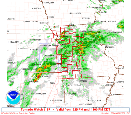
Tornado Watch Number 67
NWS Storm Prediction Center Norman OK
325 PM CDT Mon Apr 1 2024
The NWS Storm Prediction Center has issued a
* Tornado Watch for portions of
Extreme northeast Kansas
Western Missouri
* Effective this Monday afternoon and evening from 325 PM until
1100 PM CDT.
* Primary threats include…
A few tornadoes likely with a couple intense tornadoes possible
Scattered large hail and isolated very large hail events to 2.5
inches in diameter likely
Scattered damaging winds likely with isolated significant gusts
to 80 mph possible
SUMMARY…Scattered severe storm development is expected this
afternoon into this evening into western Missouri. The initial
storms will likely be supercells capable of producing isolated very
large hail (up to 2.5 inch diameter). The threat for a few
tornadoes will increase gradually through the evening with both the
supercells and any larger clusters that evolve, and a strong (EF2)
tornado or two will be possible. The threat for damaging winds
(60-80 mph) will also increase later this evening as storms grow
upscale into clusters/line segments.
The tornado watch area is approximately along and 60 statute miles
east and west of a line from 15 miles west northwest of Chillicothe
MO to 25 miles south of Monett MO. For a complete depiction of the
watch see the associated watch outline update (WOUS64 KWNS WOU7).
PRECAUTIONARY/PREPAREDNESS ACTIONS…
REMEMBER…A Tornado Watch means conditions are favorable for
tornadoes and severe thunderstorms in and close to the watch
area. Persons in these areas should be on the lookout for
threatening weather conditions and listen for later statements
and possible warnings.
&&
OTHER WATCH INFORMATION…CONTINUE…WW 64…WW 65…WW 66…
AVIATION…Tornadoes and a few severe thunderstorms with hail
surface and aloft to 2.5 inches. Extreme turbulence and surface wind
gusts to 70 knots. A few cumulonimbi with maximum tops to 500. Mean
storm motion vector 24040.
…Thompson