
WW 76 TORNADO IL IN KY MO 021710Z – 022300Z
URGENT – IMMEDIATE BROADCAST REQUESTED
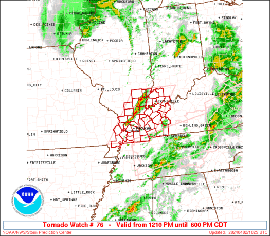
Tornado Watch Number 76
NWS Storm Prediction Center Norman OK
1210 PM CDT Tue Apr 2 2024
The NWS Storm Prediction Center has issued a
* Tornado Watch for portions of
Southeast Illinois
Southwest Indiana
Western Kentucky
Extreme southeast Missouri
* Effective this Tuesday afternoon and evening from 1210 PM until
600 PM CDT.
* Primary threats include…
A few tornadoes likely with a couple intense tornadoes possible
Scattered large hail and isolated very large hail events to 2
inches in diameter likely
Scattered damaging winds likely with isolated significant gusts
to 75 mph possible
SUMMARY…Scattered supercell development is expected along a wind
shift from extreme southeast Missouri into southeast Illinois early
this afternoon, and additional storms will form and move into
western Kentucky and southwest Indiana through the afternoon. The
environment favors fast-moving supercells capable of producing
tornadoes (a couple of which could be strong/EF2), large hail of 1-2
inches in diameter, and damaging gusts of 60-75 mph.
The tornado watch area is approximately along and 60 statute miles
east and west of a line from 40 miles north of Evansville IN to 40
miles south southwest of Paducah KY. For a complete depiction of the
watch see the associated watch outline update (WOUS64 KWNS WOU6).
PRECAUTIONARY/PREPAREDNESS ACTIONS…
REMEMBER…A Tornado Watch means conditions are favorable for
tornadoes and severe thunderstorms in and close to the watch
area. Persons in these areas should be on the lookout for
threatening weather conditions and listen for later statements
and possible warnings.
&&
OTHER WATCH INFORMATION…CONTINUE…WW 75…
AVIATION…Tornadoes and a few severe thunderstorms with hail
surface and aloft to 2 inches. Extreme turbulence and surface wind
gusts to 65 knots. A few cumulonimbi with maximum tops to 500. Mean
storm motion vector 24050.
…Thompson