
WW 77 TORNADO KY 021725Z – 030000Z
URGENT – IMMEDIATE BROADCAST REQUESTED
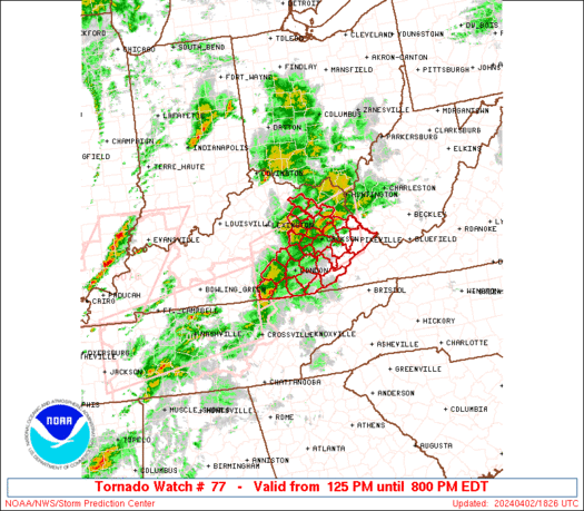
Tornado Watch Number 77
NWS Storm Prediction Center Norman OK
125 PM EDT Tue Apr 2 2024
The NWS Storm Prediction Center has issued a
* Tornado Watch for portions of
Eastern Kentucky
* Effective this Tuesday afternoon and evening from 125 PM until
800 PM EDT.
* Primary threats include…
A few tornadoes likely with a couple intense tornadoes possible
Scattered damaging winds likely with isolated significant gusts
to 75 mph possible
Scattered large hail likely with isolated very large hail events
to 2 inches in diameter possible
SUMMARY…Supercells will be possible this afternoon along a remnant
outflow boundary from storms this morning. The environment will
become more favorable for tornadoes with time through the afternoon,
and a couple of strong (EF2+) tornadoes will be possible.
Otherwise, large hail (1-2 inch diameter) and damaging gusts (60-75
mph) will also be possible.
The tornado watch area is approximately along and 45 statute miles
north and south of a line from 55 miles west of London KY to 60
miles east northeast of Jackson KY. For a complete depiction of the
watch see the associated watch outline update (WOUS64 KWNS WOU7).
PRECAUTIONARY/PREPAREDNESS ACTIONS…
REMEMBER…A Tornado Watch means conditions are favorable for
tornadoes and severe thunderstorms in and close to the watch
area. Persons in these areas should be on the lookout for
threatening weather conditions and listen for later statements
and possible warnings.
&&
OTHER WATCH INFORMATION…CONTINUE…WW 75…WW 76…
AVIATION…Tornadoes and a few severe thunderstorms with hail
surface and aloft to 2 inches. Extreme turbulence and surface wind
gusts to 65 knots. A few cumulonimbi with maximum tops to 500. Mean
storm motion vector 25045.
…Thompson