
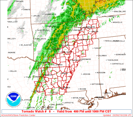
WW 8 TORNADO AR LA MS TN TX 152200Z – 160400Z
URGENT - IMMEDIATE BROADCAST REQUESTED
Tornado Watch Number 8
NWS Storm Prediction Center Norman OK
400 PM CST Sat Feb 15 2025
The NWS Storm Prediction Center has issued a
* Tornado Watch for portions of
  Eastern and Southeast Arkansas
  Northern and Central Louisiana
  Northwest Mississippi
  Western Tennessee
  East Texas
* Effective this Saturday afternoon and evening from 400 PM until
  1000 PM CST.
* Primary threats include...
  A few tornadoes likely with a couple intense tornadoes possible
  Scattered damaging wind gusts to 70 mph likely
  Isolated large hail events to 1.5 inches in diameter possible
SUMMARY...An intensifying squall line will move generally in a west
to east direction through the late evening.  The greatest severe
risk will be with bowing segments or embedded supercells or
mesovortices within the squall line, where damaging gusts are likely
and a threat for a tornadoes may exist.
The tornado watch area is approximately along and 75 statute miles
east and west of a line from 35 miles northeast of Dyersburg TN to
45 miles south of Natchitoches LA. For a complete depiction of the
watch see the associated watch outline update (WOUS64 KWNS WOU8).
PRECAUTIONARY/PREPAREDNESS ACTIONS...
REMEMBER...A Tornado Watch means conditions are favorable for
tornadoes and severe thunderstorms in and close to the watch
area. Persons in these areas should be on the lookout for
threatening weather conditions and listen for later statements
and possible warnings.
&&
AVIATION...Tornadoes and a few severe thunderstorms with hail
surface and aloft to 1.5 inches. Extreme turbulence and surface wind
gusts to 60 knots. A few cumulonimbi with maximum tops to 400. Mean
storm motion vector 21055.
...Smith