
WW 87 TORNADO DE MD NC VA CW 031635Z – 032300Z
URGENT – IMMEDIATE BROADCAST REQUESTED
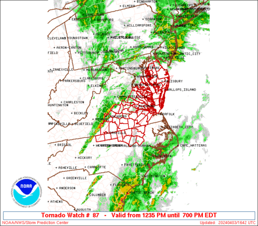
Tornado Watch Number 87
NWS Storm Prediction Center Norman OK
1235 PM EDT Wed Apr 3 2024
The NWS Storm Prediction Center has issued a
* Tornado Watch for portions of
Southern Delaware
Eastern Maryland
Northern North Carolina
Southern and eastern Virginia
Coastal Waters
* Effective this Wednesday afternoon and evening from 1235 PM
until 700 PM EDT.
* Primary threats include…
A couple tornadoes possible
Scattered damaging winds and isolated significant gusts to 75
mph possible
Isolated large hail events to 1.5 inches in diameter possible
SUMMARY…Scattered severe storm development is expected this
afternoon along and east of a surface front and deepening cyclone
moving across Virginia. The storm environment will favor a mix of
line segments and supercells capable of producing a couple of
tornadoes, damaging gusts of 60-75 mph, and isolated large hail of
1-1.5 inches in diameter.
The tornado watch area is approximately along and 60 statute miles
east and west of a line from 25 miles west northwest of Salisbury MD
to 30 miles southeast of Danville VA. For a complete depiction of
the watch see the associated watch outline update (WOUS64 KWNS
WOU7).
PRECAUTIONARY/PREPAREDNESS ACTIONS…
REMEMBER…A Tornado Watch means conditions are favorable for
tornadoes and severe thunderstorms in and close to the watch
area. Persons in these areas should be on the lookout for
threatening weather conditions and listen for later statements
and possible warnings.
&&
OTHER WATCH INFORMATION…CONTINUE…WW 85…WW 86…
AVIATION…Tornadoes and a few severe thunderstorms with hail
surface and aloft to 1.5 inches. Extreme turbulence and surface wind
gusts to 65 knots. A few cumulonimbi with maximum tops to 450. Mean
storm motion vector 23050.
…Thompson