
Microsoft today introduced a version of OneNote that is designed to run on the Apple Vision Pro headset. OneNote for Vision Pro was created for visionOS, and it includes many of the features that are available on OneNote for iPad. The app can be used to write memos, notes, and digital notebooks, and there are …
Continue reading Native Microsoft OneNote App Now Available for Apple Vision Pro
Month:April 2024
SPC MD 466

MD 0466 CONCERNING TORNADO WATCH 117…118… FOR PORTIONS OF NORTH-CENTRAL IOW AND SOUTHERN MINNESOTA. Mesoscale Discussion 0466 NWS Storm Prediction Center Norman OK 0612 PM CDT Tue Apr 16 2024 Areas affected…portions of north-central iow and southern Minnesota. Concerning…Tornado Watch 117…118… Valid 162312Z – 170015Z The severe weather threat for Tornado Watch 117, 118 continues. …
Continue reading SPC MD 466
SPC MD 465

MD 0465 CONCERNING TORNADO WATCH 117… FOR PORTIONS OF EASTERN/SOUTHEASTERN IOWA INTO NORTHWESTERN ILLINOIS Mesoscale Discussion 0465 NWS Storm Prediction Center Norman OK 0447 PM CDT Tue Apr 16 2024 Areas affected…portions of eastern/southeastern Iowa into northwestern Illinois Concerning…Tornado Watch 117… Valid 162147Z – 162315Z The severe weather threat for Tornado Watch 117 continues. SUMMARY…The …
Continue reading SPC MD 465
Everything New in the iOS 17.5 Beta
Apple is currently testing iOS 17.5, the fifth major update to the iOS 17 operating system that came out last September. Like iOS 17.4, iOS 17.5 primarily focuses on regulatory changes in the European Union, but there are a few other features worth noting. This guide aggregates everything that’s been found during the iOS 17.5 …
Continue reading Everything New in the iOS 17.5 Beta
SPC MD 463
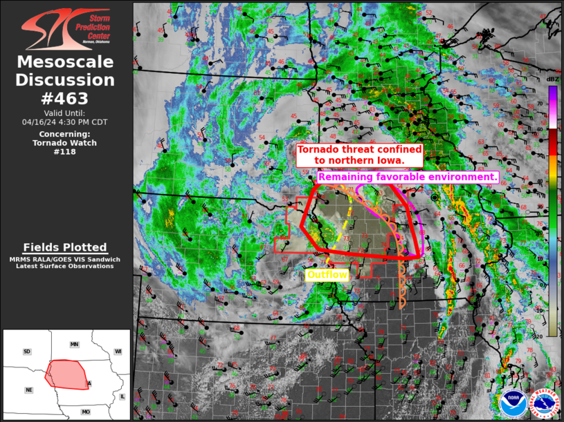
MD 0463 CONCERNING TORNADO WATCH 118… FOR NORTHERN IOWA Mesoscale Discussion 0463 NWS Storm Prediction Center Norman OK 0336 PM CDT Tue Apr 16 2024 Areas affected…Northern Iowa Concerning…Tornado Watch 118… Valid 162036Z – 162130Z The severe weather threat for Tornado Watch 118 continues. SUMMARY…The tornado threat within watch 118 is now confined to northern …
Continue reading SPC MD 463
SPC MD 464

MD 0464 CONCERNING SEVERE POTENTIAL…WATCH POSSIBLE FOR PORTIONS OF NORTHERN/CENTRAL IL Mesoscale Discussion 0464 NWS Storm Prediction Center Norman OK 0340 PM CDT Tue Apr 16 2024 Areas affected…portions of northern/central IL Concerning…Severe potential…Watch possible Valid 162040Z – 162215Z Probability of Watch Issuance…40 percent SUMMARY…Severe potential may slowly increase over the next few hours into …
Continue reading SPC MD 464
SPC MD 462

MD 0462 CONCERNING SEVERE POTENTIAL…WATCH UNLIKELY FOR CENTRAL AND EASTERN ARKANSAS Mesoscale Discussion 0462 NWS Storm Prediction Center Norman OK 0316 PM CDT Tue Apr 16 2024 Areas affected…central and eastern Arkansas Concerning…Severe potential…Watch unlikely Valid 162016Z – 162145Z Probability of Watch Issuance…20 percent SUMMARY…Isolated large hail is possible this afternoon/evening. DISCUSSION…A plume of rich …
Continue reading SPC MD 462
SPC Tornado Watch 116 Status Reports
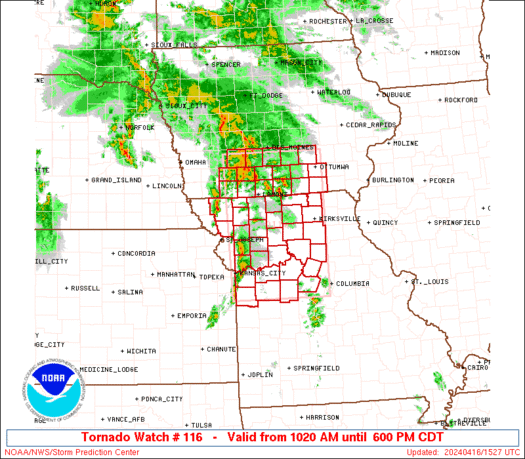
WW 0116 Status Updates STATUS REPORT ON WW 116 SEVERE WEATHER THREAT CONTINUES RIGHT OF A LINE FROM 30 ESE SZL TO 45 SW OTM TO 20 W DSM. ..LEITMAN..04/16/24 ATTN…WFO…DMX…EAX… STATUS REPORT FOR WT 116 SEVERE WEATHER THREAT CONTINUES FOR THE FOLLOWING AREAS IAC007-013-015-017-023-033-049-051-069-075-079-083-099-117-123- 125-127-135-153-157-169-171-179-181-197-162140- IA . IOWA COUNTIES INCLUDED ARE APPANOOSE BLACK HAWK …
Continue reading SPC Tornado Watch 116 Status Reports
SPC MD 461

MD 0461 CONCERNING TORNADO WATCH 118… FOR NORTHEAST NEBRASKA AND NORTHWEST IOWA Mesoscale Discussion 0461 NWS Storm Prediction Center Norman OK 0203 PM CDT Tue Apr 16 2024 Areas affected…northeast Nebraska and northwest Iowa Concerning…Tornado Watch 118… Valid 161903Z – 162030Z The severe weather threat for Tornado Watch 118 continues. SUMMARY…The hail and tornado threat …
Continue reading SPC MD 461
SPC MD 460

MD 0460 CONCERNING TORNADO WATCH 116…117… FOR NORTHERN MISSOURI INTO CENTRAL/EASTERN IOWA…NORTHWEST ILLINOIS AND EXTREME SOUTHWEST WISCONSIN Mesoscale Discussion 0460 NWS Storm Prediction Center Norman OK 0156 PM CDT Tue Apr 16 2024 Areas affected…northern Missouri into central/eastern Iowa…northwest Illinois and extreme southwest Wisconsin Concerning…Tornado Watch 116…117… Valid 161856Z – 162000Z The severe weather threat …
Continue reading SPC MD 460