
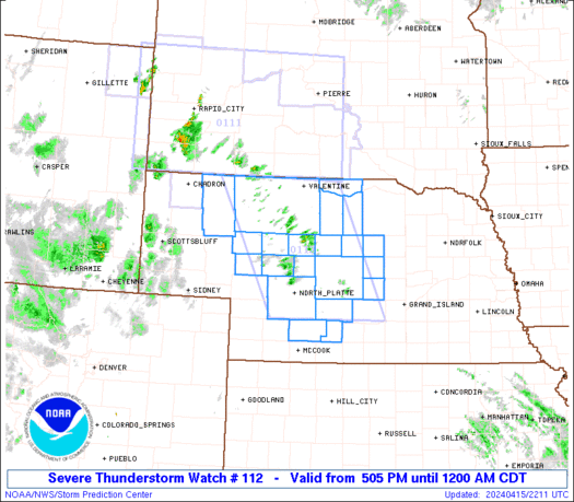
WW 112 SEVERE TSTM NE 152205Z – 160500Z URGENT – IMMEDIATE BROADCAST REQUESTED Severe Thunderstorm Watch Number 112 NWS Storm Prediction Center Norman OK 505 PM CDT Mon Apr 15 2024 The NWS Storm Prediction Center has issued a * Severe Thunderstorm Watch for portions of Central Nebraska * Effective this Monday afternoon from 505 …
Continue reading SPC Severe Thunderstorm Watch 112
Month:April 2024
Adobe Premiere Pro Gains AI Tools to Add and Remove Objects From Videos, Extend Clips and More
Adobe today debuted several new AI features for Premiere Pro, software designed for professional video editing. Adobe’s Premiere Pro is set to gain useful editing functions powered by generative AI, which will let video editors do more with less work. With a Generative Extend feature, Premiere Pro will be able to add frames to make …
Continue reading Adobe Premiere Pro Gains AI Tools to Add and Remove Objects From Videos, Extend Clips and More
SPC MD 446
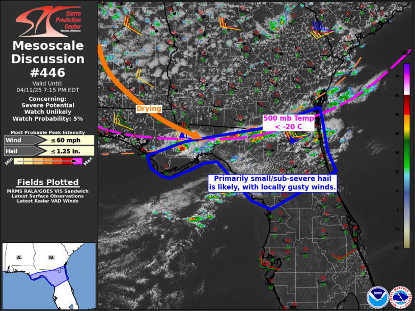
MD 0446 CONCERNING SEVERE THUNDERSTORM WATCH 109… FOR EASTERN MID ATLANTIC Mesoscale Discussion 0446 NWS Storm Prediction Center Norman OK 0557 PM CDT Mon Apr 15 2024 Areas affected…eastern Mid Atlantic Concerning…Severe Thunderstorm Watch 109… Valid 152257Z – 160030Z The severe weather threat for Severe Thunderstorm Watch 109 continues. SUMMARY…The risk for damaging gusts and …
Continue reading SPC MD 446
SPC MD 444
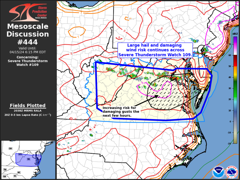
MD 0444 CONCERNING SEVERE THUNDERSTORM WATCH 109… FOR PORTIONS OF WV…VA…MD AND DE Mesoscale Discussion 0444 NWS Storm Prediction Center Norman OK 0340 PM CDT Mon Apr 15 2024 Areas affected…portions of WV…VA…MD and DE Concerning…Severe Thunderstorm Watch 109… Valid 152040Z – 152215Z The severe weather threat for Severe Thunderstorm Watch 109 continues. SUMMARY…A severe …
Continue reading SPC MD 444
SPC MD 445

MD 0445 CONCERNING SEVERE POTENTIAL…WATCH UNLIKELY FOR PORTIONS OF SOUTHEAST MISSOURI INTO SOUTHWESTERN ILLINOIS Mesoscale Discussion 0445 NWS Storm Prediction Center Norman OK 0345 PM CDT Mon Apr 15 2024 Areas affected…portions of southeast Missouri into southwestern Illinois Concerning…Severe potential…Watch unlikely Valid 152045Z – 152215Z Probability of Watch Issuance…20 percent SUMMARY…Isolated thunderstorms may develop through …
Continue reading SPC MD 445
X May Charge New Users a ‘Small Fee’ to Post, Like and Reply
Social media platform X (formerly Twitter) will soon begin charging new users “a small fee” for posting content and liking, replying, and bookmarking tweets, according to CEO Elon Musk. X Daily News, a feed that posts X updates, today noticed that text strings on the website have been updated to mention a small annual fee …
Continue reading X May Charge New Users a ‘Small Fee’ to Post, Like and Reply
Review: iVANKY’s FusionDock Max 1 Delivers Extreme Versatility With Dual Thunderbolt Connectivity
Dock accessory company iVANKY recently launched its most powerful Thunderbolt dock yet, the FusionDock Max 1, which takes advantage of dual Thunderbolt chips and connections to offer the greatest amount of versatility I’ve seen in a Mac-focused dock. I’ve spent some time testing out the FusionDock Max 1 in my daily workflow, and I think …
Continue reading Review: iVANKY’s FusionDock Max 1 Delivers Extreme Versatility With Dual Thunderbolt Connectivity
SPC MD 442

MD 0442 CONCERNING SEVERE POTENTIAL…WATCH POSSIBLE FOR SOUTHWEST SOUTH DAKOTA AND FAR NORTHERN NEBRASKA. Mesoscale Discussion 0442 NWS Storm Prediction Center Norman OK 0230 PM CDT Mon Apr 15 2024 Areas affected…Southwest South Dakota and far northern Nebraska. Concerning…Severe potential…Watch possible Valid 151930Z – 152100Z Probability of Watch Issuance…60 percent SUMMARY…Isolated thunderstorms development is possible …
Continue reading SPC MD 442
SPC MD 443

MD 0443 CONCERNING SEVERE POTENTIAL…TORNADO WATCH LIKELY FOR CENTRAL NEBRASKA INTO FAR NORTHERN KANSAS Mesoscale Discussion 0443 NWS Storm Prediction Center Norman OK 0313 PM CDT Mon Apr 15 2024 Areas affected…central Nebraska into far northern Kansas Concerning…Severe potential…Tornado Watch likely Valid 152013Z – 152145Z Probability of Watch Issuance…95 percent SUMMARY…Convective initiation is expected by …
Continue reading SPC MD 443
SPC MD 440

MD 0440 CONCERNING SEVERE POTENTIAL…TORNADO WATCH LIKELY FOR NORTHWEST TEXAS INTO THE PERMIAN BASIN Mesoscale Discussion 0440 NWS Storm Prediction Center Norman OK 0152 PM CDT Mon Apr 15 2024 Areas affected…Northwest Texas into the Permian Basin Concerning…Severe potential…Tornado Watch likely Valid 151852Z – 151945Z Probability of Watch Issuance…80 percent SUMMARY…Strong thunderstorms are expected to …
Continue reading SPC MD 440