
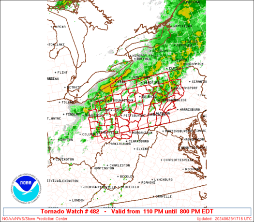
WW 482 TORNADO OH PA WV 291710Z – 300000Z URGENT – IMMEDIATE BROADCAST REQUESTED Tornado Watch Number 482 NWS Storm Prediction Center Norman OK 110 PM EDT Sat Jun 29 2024 The NWS Storm Prediction Center has issued a * Tornado Watch for portions of Eastern Ohio Western and Central Pennsylvania Northern West Virginia * …
Continue reading SPC Tornado Watch 482
Month:June 2024
SPC MD 1472

MD 1472 CONCERNING SEVERE POTENTIAL…WATCH POSSIBLE FOR PORTIONS OF OH…NORTHERN WV…AND WESTERN PA Mesoscale Discussion 1472 NWS Storm Prediction Center Norman OK 1103 AM CDT Sat Jun 29 2024 Areas affected…Portions of OH…northern WV…and western PA Concerning…Severe potential…Watch possible Valid 291603Z – 291800Z Probability of Watch Issuance…60 percent SUMMARY…Thunderstorms are expected to increase in coverage …
Continue reading SPC MD 1472
Top Stories: iOS 18 Beta 2, Apple Vision Pro International Launch, New Beats Speaker, and More
Apple is moving right along on iOS 18, macOS Sequoia, and other new operating systems that were unveiled at WWDC earlier this month, releasing the second developer betas of the updates this week with a number of new changes and additions. Public betas will follow sometime next month ahead of a full public release in …
Continue reading Top Stories: iOS 18 Beta 2, Apple Vision Pro International Launch, New Beats Speaker, and More
SPC MD 1471

MD 1471 CONCERNING SEVERE POTENTIAL…WATCH UNLIKELY FOR PARTS OF SOUTHWESTERN AND SOUTH CENTRAL NEBRASKA Mesoscale Discussion 1471 NWS Storm Prediction Center Norman OK 0151 AM CDT Sat Jun 29 2024 Areas affected…parts of southwestern and south central Nebraska Concerning…Severe potential…Watch unlikely Valid 290651Z – 290845Z Probability of Watch Issuance…20 percent SUMMARY…An isolated intense supercell may …
Continue reading SPC MD 1471
SPC Severe Thunderstorm Watch 481 Status Reports

WW 0481 Status Updates STATUS REPORT ON WW 481 THE SEVERE WEATHER THREAT CONTINUES ACROSS THE ENTIRE WATCH AREA. ..KERR..06/29/24 ATTN…WFO…SGF…EAX… STATUS REPORT FOR WS 481 SEVERE WEATHER THREAT CONTINUES FOR THE FOLLOWING AREAS KSC011-107-121-290640- KS . KANSAS COUNTIES INCLUDED ARE BOURBON LINN MIAMI MOC013-015-029-037-039-083-085-101-141-159-185-217-290640- MO . MISSOURI COUNTIES INCLUDED ARE BATES BENTON CAMDEN CASS …
Continue reading SPC Severe Thunderstorm Watch 481 Status Reports
SPC MD 1470

MD 1470 CONCERNING SEVERE THUNDERSTORM WATCH 481… FOR PORTIONS OF WESTERN MISSOURI Mesoscale Discussion 1470 NWS Storm Prediction Center Norman OK 1155 PM CDT Fri Jun 28 2024 Areas affected…portions of western Missouri Concerning…Severe Thunderstorm Watch 481… Valid 290455Z – 290630Z The severe weather threat for Severe Thunderstorm Watch 481 continues. SUMMARY…A few additional damaging …
Continue reading SPC MD 1470
SPC Severe Thunderstorm Watch 481
WW 481 SEVERE TSTM KS MO 290330Z – 290900Z URGENT – IMMEDIATE BROADCAST REQUESTED Severe Thunderstorm Watch Number 481 NWS Storm Prediction Center Norman OK 1030 PM CDT Fri Jun 28 2024 The NWS Storm Prediction Center has issued a * Severe Thunderstorm Watch for portions of Eastern Kansas West-Central Missouri * Effective this Friday …
Continue reading SPC Severe Thunderstorm Watch 481
SPC MD 1468

MD 1468 CONCERNING TORNADO WATCH 480… FOR PORTIONS OF NORTHEASTERN KANSAS INTO NORTHWESTERN MISSOURI Mesoscale Discussion 1468 NWS Storm Prediction Center Norman OK 0927 PM CDT Fri Jun 28 2024 Areas affected…portions of northeastern Kansas into northwestern Missouri Concerning…Tornado Watch 480… Valid 290227Z – 290400Z The severe weather threat for Tornado Watch 480 continues. SUMMARY…The …
Continue reading SPC MD 1468
SPC MD 1469

MD 1469 CONCERNING SEVERE POTENTIAL…WATCH UNLIKELY FOR PORTIONS OF NORTHWESTERN MINNESOTA Mesoscale Discussion 1469 NWS Storm Prediction Center Norman OK 0942 PM CDT Fri Jun 28 2024 Areas affected…portions of northwestern Minnesota Concerning…Severe potential…Watch unlikely Valid 290242Z – 290345Z Probability of Watch Issuance…5 percent SUMMARY…A localized threat for mainly severe gusts and perhaps hail will …
Continue reading SPC MD 1469
SPC Tornado Watch 480 Status Reports

WW 0480 Status Updates STATUS REPORT ON WW 480 SEVERE WEATHER THREAT CONTINUES RIGHT OF A LINE FROM EMP TO 25 WSW MHK TO 20 W FNB. ..GOSS..06/29/24 ATTN…WFO…EAX…TOP…ICT… STATUS REPORT FOR WT 480 SEVERE WEATHER THREAT CONTINUES FOR THE FOLLOWING AREAS KSC003-005-013-031-041-043-045-059-061-085-087-091-103-107-111- 121-127-131-139-149-161-177-197-209-290340- KS . KANSAS COUNTIES INCLUDED ARE ANDERSON ATCHISON BROWN COFFEY DICKINSON …
Continue reading SPC Tornado Watch 480 Status Reports