
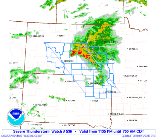
WW 536 SEVERE TSTM MN ND SD 150435Z – 151200Z URGENT – IMMEDIATE BROADCAST REQUESTED Severe Thunderstorm Watch Number 536 NWS Storm Prediction Center Norman OK 1135 PM CDT Sun Jul 14 2024 The NWS Storm Prediction Center has issued a * Severe Thunderstorm Watch for portions of Far West-Central Minnesota Central and Eastern North …
Continue reading SPC Severe Thunderstorm Watch 536
Month:July 2024
SPC Severe Thunderstorm Watch 534 Status Reports

WW 0534 Status Updates STATUS REPORT ON WW 534 SEVERE WEATHER THREAT CONTINUES RIGHT OF A LINE FROM 40 S MLI TO 25 NE BMI TO 50 N DNV TO 10 S VPZ. ..BROYLES..07/15/24 ATTN…WFO…DVN…DMX…ARX…LOT…ILX…MKX… STATUS REPORT FOR WS 534 SEVERE WEATHER THREAT CONTINUES FOR THE FOLLOWING AREAS ILC053-075-113-143-179-150840- IL . ILLINOIS COUNTIES INCLUDED ARE …
Continue reading SPC Severe Thunderstorm Watch 534 Status Reports
SPC MD 1624

MD 1624 CONCERNING SEVERE THUNDERSTORM WATCH 534… FOR PARTS OF NORTHERN TO CENTRAL IL Mesoscale Discussion 1624 NWS Storm Prediction Center Norman OK 1052 PM CDT Sun Jul 14 2024 Areas affected…parts of northern to central IL Concerning…Severe Thunderstorm Watch 534… Valid 150352Z – 150515Z The severe weather threat for Severe Thunderstorm Watch 534 continues. …
Continue reading SPC MD 1624
SPC Severe Thunderstorm Watch 535

WW 535 SEVERE TSTM IN MI LM 150345Z – 150900Z URGENT – IMMEDIATE BROADCAST REQUESTED Severe Thunderstorm Watch Number 535 NWS Storm Prediction Center Norman OK 1145 PM EDT Sun Jul 14 2024 The NWS Storm Prediction Center has issued a * Severe Thunderstorm Watch for portions of Northern Indiana Southwest Lower Michigan Lake Michigan …
Continue reading SPC Severe Thunderstorm Watch 535
SPC Severe Thunderstorm Watch 533 Status Reports

WW 0533 Status Updates STATUS REPORT ON WW 533 SEVERE WEATHER THREAT CONTINUES RIGHT OF A LINE FROM 40 ESE SDY TO 25 E ISN TO 55 N MOT. FOR ADDITIONAL INFORMATION SEE MESOSCALE DISCUSSION 1623. ..GRAMS..07/15/24 ATTN…WFO…GGW…FGF…BIS… STATUS REPORT FOR WS 533 SEVERE WEATHER THREAT CONTINUES FOR THE FOLLOWING AREAS NDC005-009-019-025-049-053-055-057-061-065-069-071-075-079-083- 095-101-103-150440- ND . …
Continue reading SPC Severe Thunderstorm Watch 533 Status Reports
SPC MD 1622
MD 1622 CONCERNING SEVERE POTENTIAL…WATCH POSSIBLE FOR NORTHEAST ILLINOIS TO NORTHERN INDIANA Mesoscale Discussion 1622 NWS Storm Prediction Center Norman OK 0936 PM CDT Sun Jul 14 2024 Areas affected…Northeast Illinois to northern Indiana Concerning…Severe potential…Watch possible Valid 150236Z – 150330Z Probability of Watch Issuance…60 percent SUMMARY…Damaging winds are expected with convection as it propagates …
Continue reading SPC MD 1622
SPC MD 1623

MD 1623 CONCERNING SEVERE THUNDERSTORM WATCH 533… FOR CENTRAL TO SOUTHEAST ND AND NORTHEAST SD Mesoscale Discussion 1623 NWS Storm Prediction Center Norman OK 0950 PM CDT Sun Jul 14 2024 Areas affected…central to southeast ND and northeast SD Concerning…Severe Thunderstorm Watch 533… Valid 150250Z – 150445Z The severe weather threat for Severe Thunderstorm Watch …
Continue reading SPC MD 1623
SPC MD 1620

MD 1620 CONCERNING SEVERE THUNDERSTORM WATCH 533… FOR PARTS OF WESTERN/CENTRAL ND Mesoscale Discussion 1620 NWS Storm Prediction Center Norman OK 0740 PM CDT Sun Jul 14 2024 Areas affected…parts of western/central ND Concerning…Severe Thunderstorm Watch 533… Valid 150040Z – 150215Z The severe weather threat for Severe Thunderstorm Watch 533 continues. SUMMARY…An increasing threat for …
Continue reading SPC MD 1620
SPC MD 1621

MD 1621 CONCERNING SEVERE THUNDERSTORM WATCH 534… FOR UPPER MIDWEST Mesoscale Discussion 1621 NWS Storm Prediction Center Norman OK 0751 PM CDT Sun Jul 14 2024 Areas affected…Upper Midwest Concerning…Severe Thunderstorm Watch 534… Valid 150051Z – 150215Z The severe weather threat for Severe Thunderstorm Watch 534 continues. SUMMARY…Severe threat will spread across northern Illinois/southern Wisconsin …
Continue reading SPC MD 1621
SPC MD 1619

MD 1619 CONCERNING SEVERE POTENTIAL…WATCH UNLIKELY FOR EASTERN OHIO INTO FAR WESTERN WEST VIRGINIA AND PENNSYLVANIA AND FAR NORTHEAST KENTUCKY Mesoscale Discussion 1619 NWS Storm Prediction Center Norman OK 0529 PM CDT Sun Jul 14 2024 Areas affected…Eastern Ohio into far western West Virginia and Pennsylvania and far northeast Kentucky Concerning…Severe potential…Watch unlikely Valid 142229Z …
Continue reading SPC MD 1619