
The iPhone 16 Pro and iPhone 16 Pro Max are rumored to feature bigger battery capacities compared to previous-generation models, but it looks like the smaller iPhone 16 Pro device could see the biggest improvement, according to new details. Chinese Weibo-based leaker Instant Digital today posted the mAh (milliampere-hours) figures for the iPhone 16 Pro …
Continue reading iPhone 16 Pro Model to Get Biggest Battery Capacity Jump
Month:August 2024
SPC MD 1793

MD 1793 CONCERNING SEVERE POTENTIAL…WATCH UNLIKELY FOR NORTHWEST/NORTH-CENTRAL OK AND EXTREME SOUTH KS Mesoscale Discussion 1793 NWS Storm Prediction Center Norman OK 1251 AM CDT Fri Aug 02 2024 Areas affected…northwest/north-central OK and extreme south KS Concerning…Severe potential…Watch unlikely Valid 020551Z – 020745Z Probability of Watch Issuance…5 percent SUMMARY…Strong to marginally severe gusts of 45-60 …
Continue reading SPC MD 1793
SPC Severe Thunderstorm Watch 589 Status Reports

WW 0589 Status Updates STATUS REPORT ON WW 589 SEVERE WEATHER THREAT CONTINUES RIGHT OF A LINE FROM 40 NNE TYS TO 45 NNW TRI TO 35 SSE HTS TO 25 N HTS. FOR ADDITIONAL INFORMATION SEE MESOSCALE DISCUSSION 1792 ..DEAN..08/02/24 ATTN…WFO…JKL…RLX… STATUS REPORT FOR WS 589 SEVERE WEATHER THREAT CONTINUES FOR THE FOLLOWING AREAS …
Continue reading SPC Severe Thunderstorm Watch 589 Status Reports
SPC MD 1792

MD 1792 CONCERNING SEVERE THUNDERSTORM WATCH 589… FOR EASTERN KY/TN INTO WESTERN VA AND EXTREME SOUTHWEST WV Mesoscale Discussion 1792 NWS Storm Prediction Center Norman OK 0801 PM CDT Thu Aug 01 2024 Areas affected…Eastern KY/TN into western VA and extreme southwest WV Concerning…Severe Thunderstorm Watch 589… Valid 020101Z – 020230Z The severe weather threat …
Continue reading SPC MD 1792
SPC Severe Thunderstorm Watch 588 Status Reports

WW 0588 Status Updates STATUS REPORT ON WW 588 SEVERE WEATHER THREAT CONTINUES RIGHT OF A LINE FROM 20 NE BWG TO 45 SW LEX TO 35 SSW LUK TO 40 ESE LUK. FOR ADDITIONAL INFORMATION SEE MESOSCALE DISCUSSION 1791 ..DEAN..08/01/24 ATTN…WFO…ILX…PAH…IND…LMK…ILN… STATUS REPORT FOR WS 588 SEVERE WEATHER THREAT CONTINUES FOR THE FOLLOWING AREAS …
Continue reading SPC Severe Thunderstorm Watch 588 Status Reports
SPC Severe Thunderstorm Watch 589
WW 589 SEVERE TSTM KY VA WV 012245Z – 020400Z URGENT – IMMEDIATE BROADCAST REQUESTED Severe Thunderstorm Watch Number 589 NWS Storm Prediction Center Norman OK 645 PM EDT Thu Aug 1 2024 The NWS Storm Prediction Center has issued a * Severe Thunderstorm Watch for portions of Eastern Kentucky Southwest Virginia Southwest West Virginia …
Continue reading SPC Severe Thunderstorm Watch 589
Apple’s Q3 2024 Earnings Call Takeaways
Apple today held an earnings call for the third fiscal quarter of 2024 (second calendar quarter), with Apple reporting its best June quarter to date, with revenue higher than expected. Apple CEO Tim Cook and Apple CFO Luca Maestri provided some insight into Apple’s performance, iPad sales, services growth, AI plans, and more. We’ve highlighted …
Continue reading Apple’s Q3 2024 Earnings Call Takeaways
SPC MD 1791

MD 1791 CONCERNING SEVERE THUNDERSTORM WATCH 588… FOR CENTRAL/EASTERN KY INTO SOUTHEAST IN…SOUTHWEST OH…AND NORTHERN TN Mesoscale Discussion 1791 NWS Storm Prediction Center Norman OK 0515 PM CDT Thu Aug 01 2024 Areas affected…Central/eastern KY into southeast IN…southwest OH…and northern TN Concerning…Severe Thunderstorm Watch 588… Valid 012215Z – 012345Z The severe weather threat for Severe …
Continue reading SPC MD 1791
Apple Reports 3Q 2024 Results: $21.4B Profit on $85.8B Revenue
Apple today announced financial results for its third fiscal quarter of 2024, which corresponds to the second calendar quarter of the year. For the quarter, Apple posted revenue of $85.8 billion and net quarterly profit of $21.4 billion, or $1.40 per diluted share, compared to revenue of $81.8 billion and net quarterly profit of $19.9 …
Continue reading Apple Reports 3Q 2024 Results: $21.4B Profit on $85.8B Revenue
SPC MD 1789
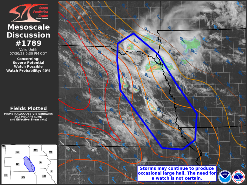
MD 1789 CONCERNING SEVERE THUNDERSTORM WATCH 588… FOR SOUTHERN INDIANA INTO CENTRAL KY Mesoscale Discussion 1789 NWS Storm Prediction Center Norman OK 0251 PM CDT Thu Aug 01 2024 Areas affected…southern Indiana into central KY Concerning…Severe Thunderstorm Watch 588… Valid 011951Z – 012115Z The severe weather threat for Severe Thunderstorm Watch 588 continues. SUMMARY…Damaging gusts …
Continue reading SPC MD 1789