
Apple on Tuesday announced new 11-inch and 13-inch iPad Air models with the M3 chip, and while the processor upgrade and updated Magic Keyboard are the biggest changes, there’s another difference in the larger model compared to its predecessor that may have gone unnoticed. For the new 13-inch iPad Air, Apple has mysteriously removed the …
Continue reading New 13-Inch iPad Air Lacks Audio Feature Found in Last-Gen Model
Month:March 2025
SPC Tornado Watch 24 Status Reports

WW 0024 Status Updates STATUS REPORT ON WW 24 SEVERE WEATHER THREAT CONTINUES RIGHT OF A LINE FROM 50 SW AAF TO 20 WNW AAF TO 35 WSW TLH TO 20 NW TLH TO 25 W MGR TO 10 E ABY TO 30 NE ABY. ..JEWELL..03/05/25 ATTN…WFO…TAE… STATUS REPORT FOR WT 24 SEVERE WEATHER THREAT …
Continue reading SPC Tornado Watch 24 Status Reports
SPC MD 145

MD 0145 CONCERNING TORNADO WATCH 24… FOR FLORIDA PANHANDLE INTO PARTS OF CENTRAL TO SOUTHERN GEORGIA Mesoscale Discussion 0145 NWS Storm Prediction Center Norman OK 0135 AM CST Wed Mar 05 2025 Areas affected…Florida Panhandle into parts of central to southern Georgia Concerning…Tornado Watch 24… Valid 050735Z – 051100Z The severe weather threat for Tornado …
Continue reading SPC MD 145
SPC Severe Thunderstorm Watch 25

WW 25 SEVERE TSTM FL GA SC CW 050815Z – 051500Z URGENT – IMMEDIATE BROADCAST REQUESTED Severe Thunderstorm Watch Number 25 NWS Storm Prediction Center Norman OK 315 AM EST Wed Mar 5 2025 The NWS Storm Prediction Center has issued a * Severe Thunderstorm Watch for portions of North Florida Southern into Southeast Georgia …
Continue reading SPC Severe Thunderstorm Watch 25
SPC MD 144

MD 0144 CONCERNING SEVERE THUNDERSTORM WATCH 23… FOR FAR EASTERN ALABAMA AND NORTHWESTERN GEORGIA Mesoscale Discussion 0144 NWS Storm Prediction Center Norman OK 1136 PM CST Tue Mar 04 2025 Areas affected…Far eastern Alabama and northwestern Georgia Concerning…Severe Thunderstorm Watch 23… Valid 050536Z – 050730Z The severe weather threat for Severe Thunderstorm Watch 23 continues. …
Continue reading SPC MD 144
SPC MD 142

MD 0142 CONCERNING SEVERE POTENTIAL…TORNADO WATCH LIKELY FOR FLORIDA PANHANDLE…SOUTHEAST ALABAMA…SOUTHWEST GEORGIA Mesoscale Discussion 0142 NWS Storm Prediction Center Norman OK 1028 PM CST Tue Mar 04 2025 Areas affected…Florida Panhandle…Southeast Alabama…Southwest Georgia Concerning…Severe potential…Tornado Watch likely Valid 050428Z – 050530Z Probability of Watch Issuance…80 percent SUMMARY…New Tornado Watch appears warranted. DISCUSSION…Mid 60s surface dew …
Continue reading SPC MD 142
SPC MD 143

MD 0143 CONCERNING BLIZZARD FOR PORTIONS OF WESTERN AND CENTRAL IOWA INTO SOUTHERN MINNESOTA Mesoscale Discussion 0143 NWS Storm Prediction Center Norman OK 1117 PM CST Tue Mar 04 2025 Areas affected…portions of western and central Iowa into southern Minnesota Concerning…Blizzard Valid 050517Z – 050915Z SUMMARY…Heavy snow should occur for at least a few more …
Continue reading SPC MD 143
SPC Tornado Watch 22 Status Reports
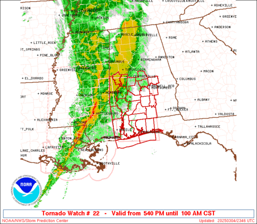
WW 0022 Status Updates STATUS REPORT ON WW 22 SEVERE WEATHER THREAT CONTINUES RIGHT OF A LINE FROM 35 SW PNS TO 10 E MGM. ..SPC..03/05/25 ATTN…WFO…BMX…MOB… STATUS REPORT FOR WT 22 SEVERE WEATHER THREAT CONTINUES FOR THE FOLLOWING AREAS ALC013-035-039-041-051-053-101-050540- AL . ALABAMA COUNTIES INCLUDED ARE BUTLER CONECUH COVINGTON CRENSHAW ELMORE ESCAMBIA MONTGOMERY FLC033-091-113-050540- …
Continue reading SPC Tornado Watch 22 Status Reports
SPC Severe Thunderstorm Watch 23 Status Reports
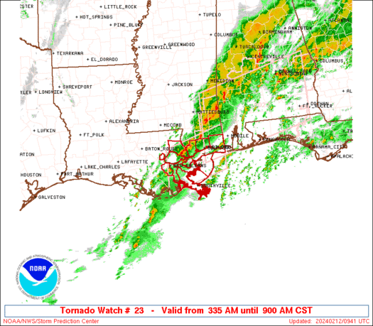
WW 0023 Status Updates STATUS REPORT ON WW 23 SEVERE WEATHER THREAT CONTINUES RIGHT OF A LINE FROM 25 S MGM TO 30 WNW AUO TO 30 WSW CHA. ..SPC..03/05/25 ATTN…WFO…BMX…HUN…FFC… STATUS REPORT FOR WS 23 SEVERE WEATHER THREAT CONTINUES FOR THE FOLLOWING AREAS ALC005-011-015-017-019-027-029-049-055-081-087-109-111-113-123- 050540- AL . ALABAMA COUNTIES INCLUDED ARE BARBOUR BULLOCK CALHOUN …
Continue reading SPC Severe Thunderstorm Watch 23 Status Reports
SPC Tornado Watch 24
WW 24 TORNADO AL FL GA CW 050450Z – 051200Z URGENT – IMMEDIATE BROADCAST REQUESTED Tornado Watch Number 24 NWS Storm Prediction Center Norman OK 1050 PM CST Tue Mar 4 2025 The NWS Storm Prediction Center has issued a * Tornado Watch for portions of Southeast Alabama Florida Panhandle Southwest Georgia Coastal Waters * …
Continue reading SPC Tornado Watch 24