
WW 429 SEVERE TSTM IA MN WI 172205Z – 180500Z
URGENT – IMMEDIATE BROADCAST REQUESTED
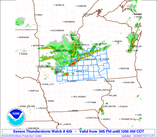
Severe Thunderstorm Watch Number 429
NWS Storm Prediction Center Norman OK
505 PM CDT Mon Jun 17 2024
The NWS Storm Prediction Center has issued a
* Severe Thunderstorm Watch for portions of
Northern Iowa
Southern Minnesota
Southwestern Wisconsin
* Effective this Monday afternoon from 505 PM until Midnight CDT.
* Primary threats include…
Scattered large hail and isolated very large hail events to 2.5
inches in diameter possible
Scattered damaging wind gusts to 70 mph possible
A tornado or two possible
SUMMARY…Thunderstorms are expected to increase in coverage the
next few hours near an outflow-reinforced warm front that will shift
northward through the watch area. In addition to supercell(s) with
large hail and a localized/conditional tornado threat, broader
severe-hail and severe-gust threats also are apparent on either side
of the boundary.
The severe thunderstorm watch area is approximately along and 50
statute miles north and south of a line from 40 miles south
southwest of Fairmont MN to 45 miles east southeast of La Crosse WI.
For a complete depiction of the watch see the associated watch
outline update (WOUS64 KWNS WOU9).
PRECAUTIONARY/PREPAREDNESS ACTIONS…
REMEMBER…A Severe Thunderstorm Watch means conditions are
favorable for severe thunderstorms in and close to the watch area.
Persons in these areas should be on the lookout for threatening
weather conditions and listen for later statements and possible
warnings. Severe thunderstorms can and occasionally do produce
tornadoes.
&&
AVIATION…A few severe thunderstorms with hail surface and aloft to
2.5 inches. Extreme turbulence and surface wind gusts to 60 knots. A
few cumulonimbi with maximum tops to 550. Mean storm motion vector
26025.
…Edwards