
WW 518 SEVERE TSTM DC MD PA VA WV CW 101740Z – 110200Z
URGENT – IMMEDIATE BROADCAST REQUESTED
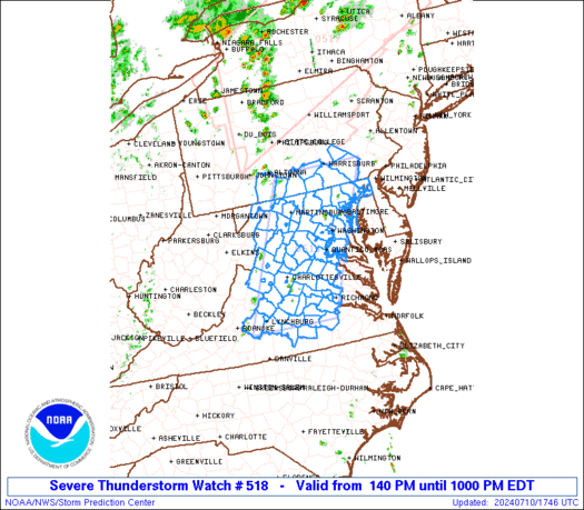
Severe Thunderstorm Watch Number 518
NWS Storm Prediction Center Norman OK
140 PM EDT Wed Jul 10 2024
The NWS Storm Prediction Center has issued a
* Severe Thunderstorm Watch for portions of
District Of Columbia
Maryland
Southern Pennsylvania
Virginia
Far Eastern West Virginia
Coastal Waters
* Effective this Wednesday afternoon and evening from 140 PM
until 1000 PM EDT.
* Primary threats include…
Scattered damaging wind gusts to 65 mph likely
A tornado or two possible
SUMMARY…Scattered storms will continue to develop and intensify
across the region, with the most sustained storms potentially
focused across southern Pennsylvania, interior Maryland, into
northern/central Virginia. Damaging winds will be the most common
severe concern.
The severe thunderstorm watch area is approximately along and 60
statute miles east and west of a line from 50 miles northeast of
Hagerstown MD to 40 miles east southeast of Lynchburg VA. For a
complete depiction of the watch see the associated watch outline
update (WOUS64 KWNS WOU8).
PRECAUTIONARY/PREPAREDNESS ACTIONS…
REMEMBER…A Severe Thunderstorm Watch means conditions are
favorable for severe thunderstorms in and close to the watch area.
Persons in these areas should be on the lookout for threatening
weather conditions and listen for later statements and possible
warnings. Severe thunderstorms can and occasionally do produce
tornadoes.
&&
OTHER WATCH INFORMATION…CONTINUE…WW 517…
AVIATION…A few severe thunderstorms with hail surface and aloft to
1 inch. Extreme turbulence and surface wind gusts to 55 knots. A few
cumulonimbi with maximum tops to 550. Mean storm motion vector
24025.
…Guyer