SPC 0830Z Day 3 Outlook Day 3 Convective Outlook NWS Storm Prediction Center Norman OK 0231 AM CST Fri Jan 30 2026 Valid 011200Z – 021200Z …NO THUNDERSTORM AREAS FORECAST… …SUMMARY… Thunderstorms are not forecast across the U.S. on Sunday or Sunday night. …DISCUSSION… An upper-level trough will move from near the southern Atlantic Seaboard …
Continue reading SPC Jan 30, 2026 0830 UTC Day 3 Severe Thunderstorm Outlook
Author:Ken
SPC Jan 30, 2026 0700 UTC Day 2 Convective Outlook
SPC 0700Z Day 2 Outlook Day 2 Convective Outlook NWS Storm Prediction Center Norman OK 1241 AM CST Fri Jan 30 2026 Valid 311200Z – 011200Z …NO THUNDERSTORM AREAS FORECAST… …SUMMARY… Thunderstorms are not forecast across the U.S. on Saturday and Saturday night. …DISCUSSION… An upper-level trough will move through the Southeast on Saturday, as …
Continue reading SPC Jan 30, 2026 0700 UTC Day 2 Convective Outlook
SPC Jan 30, 2026 0600 UTC Day 1 Convective Outlook
SPC 1200Z Day 1 Outlook Day 1 Convective Outlook NWS Storm Prediction Center Norman OK 1141 PM CST Thu Jan 29 2026 Valid 301200Z – 311200Z …NO THUNDERSTORM AREAS FORECAST… …SUMMARY… Thunderstorms are not expected today or tonight. …Synopsis/Discussion… A longwave trough will remain steadfast east of the Rockies, with upper ridging prevalent over much …
Continue reading SPC Jan 30, 2026 0600 UTC Day 1 Convective Outlook
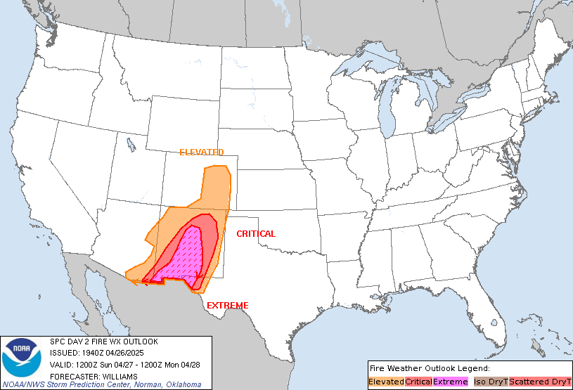
SPC Day 2 Fire Weather Outlook
SPC Day 2 Fire Weather Outlook Day 2 Fire Weather Outlook NWS Storm Prediction Center Norman OK 1136 PM CST Thu Jan 29 2026 Valid 311200Z – 011200Z …NO CRITICAL AREAS… …Synopsis… A strong upper trough will continue to pivot through the Southeast on Saturday. A low pressure system will deepen off the East Coast. …
Continue reading SPC Day 2 Fire Weather Outlook
SPC Day 1 Fire Weather Outlook
SPC Day 1 Fire Weather Outlook Day 1 Fire Weather Outlook NWS Storm Prediction Center Norman OK 1135 PM CST Thu Jan 29 2026 Valid 301200Z – 311200Z …NO CRITICAL AREAS… …Synopsis… Fire weather concerns will be minimal across the CONUS today. Surface high pressure and colder air will filter into areas east of the …
Continue reading SPC Day 1 Fire Weather Outlook
SPC Jan 30, 2026 0100 UTC Day 1 Convective Outlook
SPC 0100Z Day 1 Outlook Day 1 Convective Outlook NWS Storm Prediction Center Norman OK 0643 PM CST Thu Jan 29 2026 Valid 300100Z – 301200Z …NO THUNDERSTORM AREAS FORECAST… …SUMMARY… Thunderstorms are not forecast through tonight. …Discussion… The general prevalence of cold/stable conditions will preclude thunderstorm development across the CONUS through tonight. ..Guyer.. 01/30/2026 …
Continue reading SPC Jan 30, 2026 0100 UTC Day 1 Convective Outlook
SPC – No watches are valid as of Fri Jan 30 00:34:01 UTC 2026
No watches are valid as of Fri Jan 30 00:34:01 UTC 2026. Read More
SPC – No MDs are in effect as of Fri Jan 30 00:34:01 UTC 2026
No Mesoscale Discussions are in effect as of Fri Jan 30 00:34:01 UTC 2026. Read More
Apple Was Caught Off Guard by AirPods Pro 3 Popularity
AirPods Pro 3 demand was so strong after the earbuds launched in September that their popularity reportedly “caught Apple off guard.” “AirPods Pro 3 were supply-constrained during the quarter, and we think we would have grown year over year if we would not have been constrained,” Apple CEO Tim Cook told Reuters, in a report …
Continue reading Apple Was Caught Off Guard by AirPods Pro 3 Popularity
Apple Responds to Fast-Rising RAM and Storage Chip Prices
On an earnings call with equity analysts today, Apple CEO Tim Cook responded to fast-rising RAM and SSD storage chip prices in the supply chain. Cook said that rising memory chip prices had a “minimal impact” on Apple’s gross margin in the fourth quarter of the 2025 calendar year, but he does expect a “bit …
Continue reading Apple Responds to Fast-Rising RAM and Storage Chip Prices


