
Even without any announcements from Apple, CES dominated tech news this week with a host of upcoming products and technologies being demonstrated at the annual expo in Las Vegas. Other news in the Apple world this week included official word that the Apple Card will shift from Goldman Sachs to Chase, while iOS 26 appears …
Continue reading Top Stories: CES 2026 Highlights, Apple Card Moving to Chase, and More
Author:Ken
SPC MD 19

MD 0019 CONCERNING TORNADO WATCH 3… FOR PARTS OF SOUTHEASTERN MS AND SOUTHWESTERN THROUGH CENTRAL AL Mesoscale Discussion 0019 NWS Storm Prediction Center Norman OK 0704 AM CST Sat Jan 10 2026 Areas affected…parts of southeastern MS and southwestern through central AL Concerning…Tornado Watch 3… Valid 101304Z – 101500Z The severe weather threat for Tornado …
Continue reading SPC MD 19
SPC Jan 10, 2026 1300 UTC Day 1 Convective Outlook

SPC 1300Z Day 1 Outlook Day 1 Convective Outlook NWS Storm Prediction Center Norman OK 0614 AM CST Sat Jan 10 2026 Valid 101300Z – 111200Z …THERE IS A SLIGHT RISK OF SEVERE THUNDERSTORMS THIS MORNING AND EARLY AFTERNOON FROM CENTRAL LOUISIANA TO WESTERN GEORGIA… …SUMMARY… A few severe thunderstorms are forecast this morning and …
Continue reading SPC Jan 10, 2026 1300 UTC Day 1 Convective Outlook
Apple’s MacBook Pro Turns 20 Years Old
Today marks the 20th anniversary of the introduction of the MacBook Pro, unveiled by Steve Jobs as a “One More Thing” segment at the end of his Macworld San Francisco keynote on January 10, 2006. The MacBook Pro was an evolution of the previous PowerBook as the professional-level laptop in Apple’s lineup, but with the …
Continue reading Apple’s MacBook Pro Turns 20 Years Old
SPC Tornado Watch 3
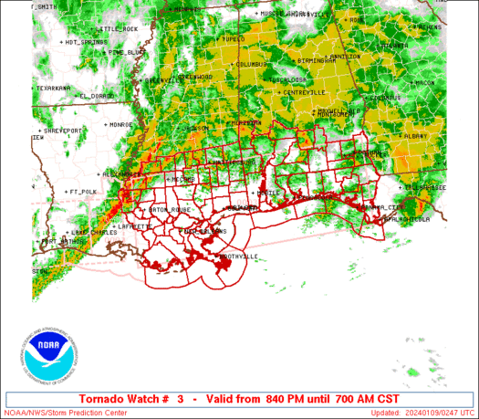
WW 3 TORNADO AL GA MS 100950Z – 101600Z URGENT – IMMEDIATE BROADCAST REQUESTED Tornado Watch Number 3 NWS Storm Prediction Center Norman OK 350 AM CST Sat Jan 10 2026 The NWS Storm Prediction Center has issued a * Tornado Watch for portions of Central Alabama Northwest Georgia Southeast Mississippi * Effective this Saturday …
Continue reading SPC Tornado Watch 3
SPC Jan 10, 2026 Day 4-8 Severe Weather Outlook

Day 4-8 Outlook Day 4-8 Convective Outlook NWS Storm Prediction Center Norman OK 0340 AM CST Sat Jan 10 2026 Valid 131200Z – 181200Z …DISCUSSION… A large-scale upper-level trough is forecast to develop across the central and eastern U.S. during the mid-week. This feature is forecast to move eastward toward the Atlantic Seaboard late in …
Continue reading SPC Jan 10, 2026 Day 4-8 Severe Weather Outlook
SPC Tornado Watch 2 Status Reports
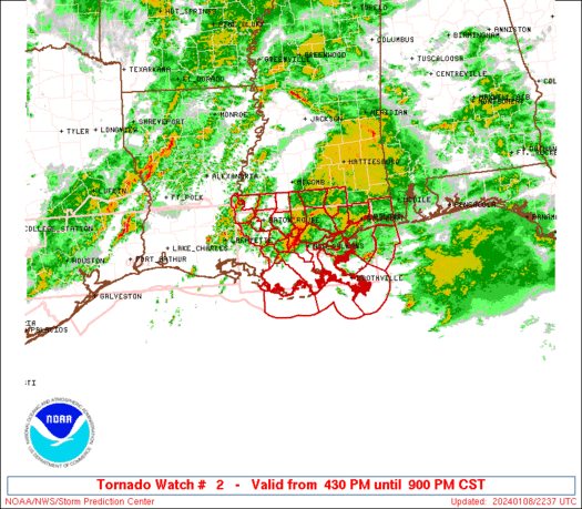
WW 0002 Status Updates STATUS REPORT ON WW 2 SEVERE WEATHER THREAT CONTINUES RIGHT OF A LINE FROM 20 SE POE TO 30 NW HEZ TO 60 NNE HEZ. A NEW WW WILL BE ISSUED PRIOR TO 10/10Z SCHEDULED EXPIRATION OF WW 2. ..KERR..01/10/26 ATTN…WFO…LCH…SHV…JAN…LIX…MOB… STATUS REPORT FOR WT 2 SEVERE WEATHER THREAT CONTINUES FOR …
Continue reading SPC Tornado Watch 2 Status Reports
SPC Jan 10, 2026 0830 UTC Day 3 Severe Thunderstorm Outlook

SPC 0830Z Day 3 Outlook Day 3 Convective Outlook NWS Storm Prediction Center Norman OK 0225 AM CST Sat Jan 10 2026 Valid 121200Z – 131200Z …NO THUNDERSTORM AREAS FORECAST… …SUMMARY… Thunderstorms are not expected across the U.S. on Monday and Monday night. …DISCUSSION… A large-scale upper-level trough will remain over the eastern U.S. on …
Continue reading SPC Jan 10, 2026 0830 UTC Day 3 Severe Thunderstorm Outlook
SPC MD 18

MD 0018 CONCERNING TORNADO WATCH 2… FOR PARTS OF SOUTH CENTRAL MISSISSIPPI AND ADJACENT PORTIONS OF WESTERN ALABAMA Mesoscale Discussion 0018 NWS Storm Prediction Center Norman OK 0204 AM CST Sat Jan 10 2026 Areas affected…parts of south central Mississippi and adjacent portions of western Alabama Concerning…Tornado Watch 2… Valid 100804Z – 101000Z The severe …
Continue reading SPC MD 18
SPC Jan 10, 2026 0700 UTC Day 2 Convective Outlook

SPC 0700Z Day 2 Outlook Day 2 Convective Outlook NWS Storm Prediction Center Norman OK 1243 AM CST Sat Jan 10 2026 Valid 111200Z – 121200Z …NO THUNDERSTORM AREAS FORECAST… …SUMMARY… Thunderstorms are not expected across the U.S. on Sunday or Sunday night. …DISCUSSION… An upper-level trough over the mid Mississippi Valley will move to …
Continue reading SPC Jan 10, 2026 0700 UTC Day 2 Convective Outlook