
MD 2177 CONCERNING SEVERE THUNDERSTORM WATCH 631… FOR PARTS OF SOUTHEAST TEXAS Mesoscale Discussion 2177 NWS Storm Prediction Center Norman OK 0316 AM CDT Sat Oct 25 2025 Areas affected…Parts of southeast Texas Concerning…Severe Thunderstorm Watch 631… Valid 250816Z – 251015Z The severe weather threat for Severe Thunderstorm Watch 631 continues. SUMMARY…Damaging wind gusts and …
Continue reading SPC MD 2177
Category:Weather
SPC Severe Thunderstorm Watch 630 Status Reports

WW 0630 Status Updates STATUS REPORT ON WW 630 SEVERE WEATHER THREAT CONTINUES RIGHT OF A LINE FROM 30 NNW DRT TO 35 SSE AUS TO 5 SE CRS. FOR ADDITIONAL INFORMATION SEE MESOSCALE DISCUSSION 2176 ..WEINMAN..10/25/25 ATTN…WFO…EWX…FWD…HGX… STATUS REPORT FOR WS 630 SEVERE WEATHER THREAT CONTINUES FOR THE FOLLOWING AREAS TXC019-021-029-041-051-055-137-149-161-185-187-225-271-287-289- 313-325-331-385-395-455-463-465-471-477-250740- TX . …
Continue reading SPC Severe Thunderstorm Watch 630 Status Reports
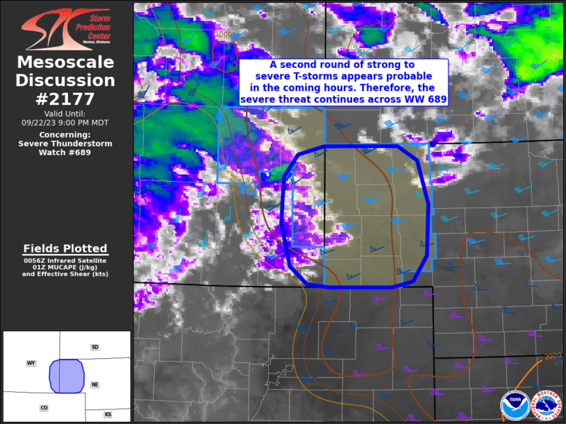
SPC Severe Thunderstorm Watch 631

WW 631 SEVERE TSTM LA TX CW 250635Z – 251200Z URGENT – IMMEDIATE BROADCAST REQUESTED Severe Thunderstorm Watch Number 631 NWS Storm Prediction Center Norman OK 135 AM CDT Sat Oct 25 2025 The NWS Storm Prediction Center has issued a * Severe Thunderstorm Watch for portions of Southwest Louisiana Southeast Texas Coastal Waters * …
Continue reading SPC Severe Thunderstorm Watch 631
SPC MD 2176

MD 2176 CONCERNING SEVERE POTENTIAL…WATCH LIKELY FOR PARTS OF SOUTHEAST TEXAS Mesoscale Discussion 2176 NWS Storm Prediction Center Norman OK 1256 AM CDT Sat Oct 25 2025 Areas affected…Parts of Southeast Texas Concerning…Severe potential…Watch likely Valid 250556Z – 250730Z Probability of Watch Issuance…80 percent SUMMARY…The severe risk will continue spreading east-southeastward to the Texas Coast …
Continue reading SPC MD 2176
SPC MD 2175
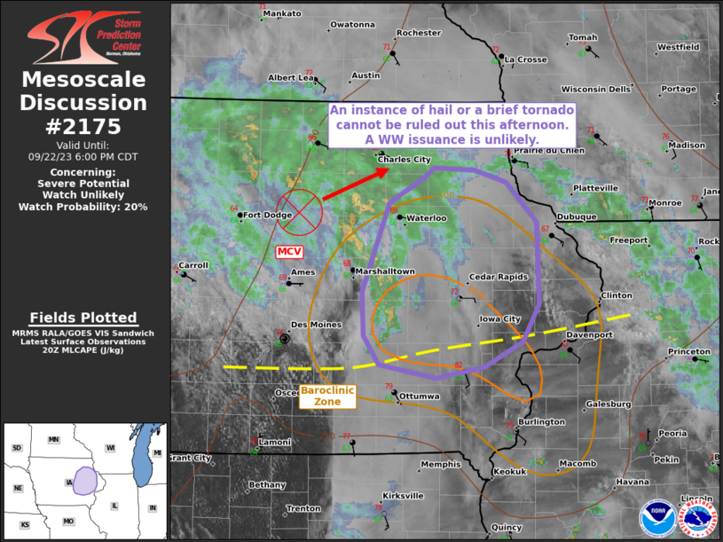
MD 2175 CONCERNING SEVERE THUNDERSTORM WATCH 630… FOR PARTS OF SOUTH CENTRAL TEXAS Mesoscale Discussion 2175 NWS Storm Prediction Center Norman OK 1049 PM CDT Fri Oct 24 2025 Areas affected…parts of south central Texas Concerning…Severe Thunderstorm Watch 630… Valid 250349Z – 250545Z The severe weather threat for Severe Thunderstorm Watch 630 continues. SUMMARY…Strong wind …
Continue reading SPC MD 2175
SPC Severe Thunderstorm Watch 629 Status Reports

WW 0629 Status Updates STATUS REPORT ON WW 629 SEVERE WEATHER THREAT CONTINUES RIGHT OF A LINE FROM 20 E DAL TO 20 SSE DUA. REMAINING VALID PORTION OF WW 629 MAY BE ALLOWED TO EXPIRE AT 25/05Z. ..KERR..10/25/25 ATTN…WFO…FWD…SJT… STATUS REPORT FOR WS 629 SEVERE WEATHER THREAT CONTINUES FOR THE FOLLOWING AREAS TXC257-349-397-250500- TX …
Continue reading SPC Severe Thunderstorm Watch 629 Status Reports
SPC MD 2174
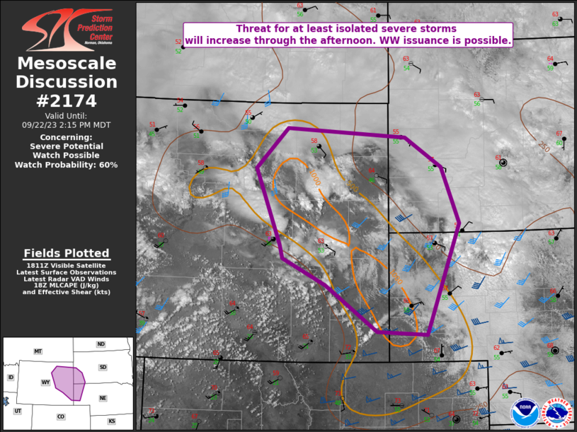
MD 2174 CONCERNING SEVERE THUNDERSTORM WATCH 629… FOR PORTIONS OF NORTH/CENTRAL TEXAS Mesoscale Discussion 2174 NWS Storm Prediction Center Norman OK 0933 PM CDT Fri Oct 24 2025 Areas affected…Portions of North/Central Texas Concerning…Severe Thunderstorm Watch 629… Valid 250233Z – 250430Z The severe weather threat for Severe Thunderstorm Watch 629 continues. SUMMARY…A mesovortex circulation will …
Continue reading SPC MD 2174
SPC Severe Thunderstorm Watch 630
WW 630 SEVERE TSTM TX 250115Z – 250800Z URGENT – IMMEDIATE BROADCAST REQUESTED Severe Thunderstorm Watch Number 630 NWS Storm Prediction Center Norman OK 815 PM CDT Fri Oct 24 2025 The NWS Storm Prediction Center has issued a * Severe Thunderstorm Watch for portions of Central Texas * Effective this Friday night and Saturday …
Continue reading SPC Severe Thunderstorm Watch 630
SPC MD 2173
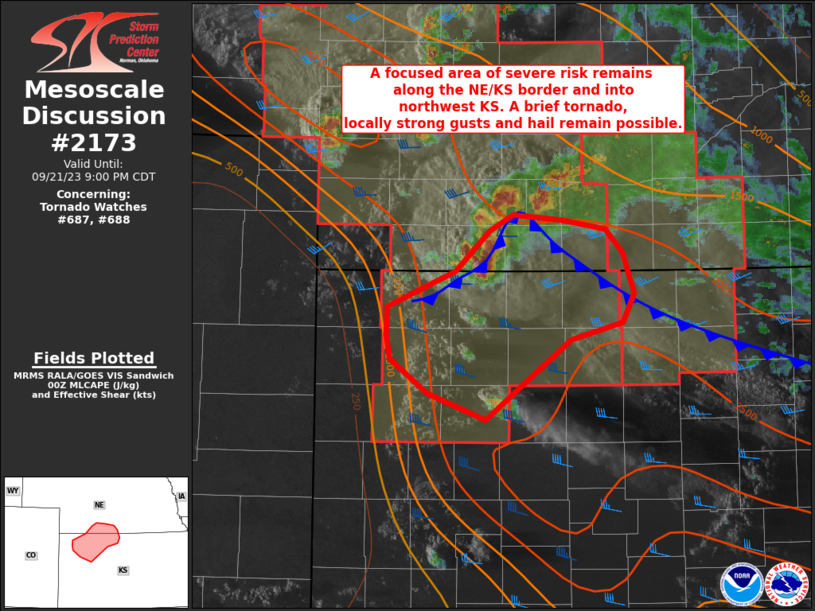
MD 2173 CONCERNING SEVERE THUNDERSTORM WATCH 629… FOR DFW VICINITY Mesoscale Discussion 2173 NWS Storm Prediction Center Norman OK 0711 PM CDT Fri Oct 24 2025 Areas affected…DFW Vicinity Concerning…Severe Thunderstorm Watch 629… Valid 250011Z – 250145Z The severe weather threat for Severe Thunderstorm Watch 629 continues. SUMMARY…A linear segment of storms will pose some …
Continue reading SPC MD 2173
SPC MD 2172

MD 2172 CONCERNING SEVERE POTENTIAL…WATCH POSSIBLE FOR PARTS OF THE TEXAS EDWARDS PLATEAU AND ADJACENT RIO GRANDE VALLEY INTO SOUTH CENTRAL TEXAS Mesoscale Discussion 2172 NWS Storm Prediction Center Norman OK 0621 PM CDT Fri Oct 24 2025 Areas affected…parts of the Texas Edwards Plateau and adjacent Rio Grande Valley into south central Texas Concerning…Severe …
Continue reading SPC MD 2172