

MD 0063 CONCERNING TORNADO WATCH 4… FOR CENTRAL/EASTERN FL PANHANDLE AND SOUTHERN GA Mesoscale Discussion 0063 NWS Storm Prediction Center Norman OK 0255 PM CST Sun Jan 25 2026 Areas affected…central/eastern FL Panhandle and southern GA Concerning…Tornado Watch 4… Valid 252055Z – 252230Z The severe weather threat for Tornado Watch 4 continues. SUMMARY…Lingering damaging wind …
Continue reading SPC MD 63
Category:Weather
SPC MD 62

MD 0062 CONCERNING FREEZING RAIN FOR WESTERN NORTH CAROLINA AND SOUTHWEST VIRGINIA Mesoscale Discussion 0062 NWS Storm Prediction Center Norman OK 0227 PM CST Sun Jan 25 2026 Areas affected…western North Carolina and southwest Virginia Concerning…Freezing rain Valid 252027Z – 252330Z SUMMARY…Mostly freezing rain with some sleet expected this afternoon into the early evening. DISCUSSION…Temperatures …
Continue reading SPC MD 62
SPC MD 61
MD 0061 CONCERNING WINTER MIXED PRECIPITATION FOR NORTHERN VIRGINIA…EASTERN WEST VIRGINIA…SOUTHERN PENNSYLVANIA…MARYLAND…DELAWARE…AND NEW JERSEY INTO LONG ISLAND. Mesoscale Discussion 0061 NWS Storm Prediction Center Norman OK 0202 PM CST Sun Jan 25 2026 Areas affected…Northern Virginia…Eastern West Virginia…Southern Pennsylvania…Maryland…Delaware…and New Jersey into Long Island. Concerning…Winter mixed precipitation Valid 252002Z – 260000Z SUMMARY…Sleet continues this afternoon. …
Continue reading SPC MD 61
SPC MD 60

MD 0060 CONCERNING TORNADO WATCH 4… FOR THE FL PANHANDLE…SOUTHWEST GA…SOUTHEAST AL Mesoscale Discussion 0060 NWS Storm Prediction Center Norman OK 1232 PM CST Sun Jan 25 2026 Areas affected…the FL Panhandle…southwest GA…southeast AL Concerning…Tornado Watch 4… Valid 251832Z – 252000Z The severe weather threat for Tornado Watch 4 continues. SUMMARY…Sporadic damaging winds and potential …
Continue reading SPC MD 60
SPC MD 59

MD 0059 CONCERNING FREEZING RAIN FOR NORTHEAST GEORGIA…WESTERN SOUTH CAROLINA…AND PARTS OF WESTERN NORTH CAROLINA Mesoscale Discussion 0059 NWS Storm Prediction Center Norman OK 1157 AM CST Sun Jan 25 2026 Areas affected…northeast Georgia…western South Carolina…and parts of western North Carolina Concerning…Freezing rain Valid 251757Z – 252200Z SUMMARY…Heavy freezing rain is expected between 19Z and …
Continue reading SPC MD 59
SPC MD 58

MD 0058 CONCERNING HEAVY SNOW FOR NORTHERN PENNSYLVANIA…SOUTHERN NEW YORK…NORTHERN NEW JERSEY…CONNECTICUT…RHODE ISLAND…AND SOUTHERN MASSACHUSETTS. Mesoscale Discussion 0058 NWS Storm Prediction Center Norman OK 1055 AM CST Sun Jan 25 2026 Areas affected…northern Pennsylvania…southern New York…northern New Jersey…Connecticut…Rhode Island…and southern Massachusetts. Concerning…Heavy snow Valid 251655Z – 252100Z SUMMARY…Heavy snowfall is expected through the afternoon with …
Continue reading SPC MD 58
SPC Tornado Watch 4
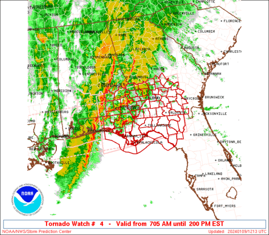
WW 4 TORNADO AL FL GA CW 251650Z – 260000Z URGENT – IMMEDIATE BROADCAST REQUESTED Tornado Watch Number 4 NWS Storm Prediction Center Norman OK 1050 AM CST Sun Jan 25 2026 The NWS Storm Prediction Center has issued a * Tornado Watch for portions of Southeast Alabama Western Florida Panhandle Southwest Georgia Coastal Waters …
Continue reading SPC Tornado Watch 4
SPC MD 57

MD 0057 CONCERNING SEVERE POTENTIAL…TORNADO WATCH LIKELY FOR SOUTHERN AL…FL PANHANDLE…SOUTHWEST GA Mesoscale Discussion 0057 NWS Storm Prediction Center Norman OK 0955 AM CST Sun Jan 25 2026 Areas affected…southern AL…FL Panhandle…southwest GA Concerning…Severe potential…Tornado Watch likely Valid 251555Z – 251800Z Probability of Watch Issuance…80 percent SUMMARY…Severe potential will likely increase into early afternoon with …
Continue reading SPC MD 57
SPC MD 56
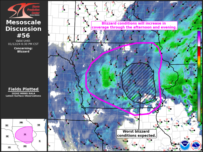
MD 0056 CONCERNING HEAVY SNOW FOR CENTRAL INDIANA TO WESTERN PENNSYLVANIA Mesoscale Discussion 0056 NWS Storm Prediction Center Norman OK 0900 AM CST Sun Jan 25 2026 Areas affected…Central Indiana to Western Pennsylvania Concerning…Heavy snow Valid 251500Z – 251800Z SUMMARY…Moderate to heavy snow rates to continue through the morning. DISCUSSION…A broad zone of isentropic ascent …
Continue reading SPC MD 56
SPC MD 55

MD 0055 CONCERNING WINTER MIXED PRECIPITATION FOR EASTERN WEST VIRGINIA AND VIRGINIA INTO THE DELMARVA. Mesoscale Discussion 0055 NWS Storm Prediction Center Norman OK 0839 AM CST Sun Jan 25 2026 Areas affected…Eastern West Virginia and Virginia into the DelMarva. Concerning…Winter mixed precipitation Valid 251439Z – 251745Z SUMMARY…Snow has mostly transitioned to sleet from eastern …
Continue reading SPC MD 55