
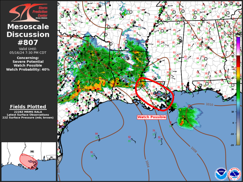
MD 0807 CONCERNING SEVERE POTENTIAL…WATCH POSSIBLE FOR LOWER MISSISSIPPI VALLEY Mesoscale Discussion 0807 NWS Storm Prediction Center Norman OK 0531 PM CDT Thu May 16 2024 Areas affected…Lower Mississippi Valley Concerning…Severe potential…Watch possible Valid 162231Z – 170030Z Probability of Watch Issuance…40 percent SUMMARY…Severe threat is expected to gradually increase across the lower MS Valley this …
Continue reading SPC MD 807
Category:Weather
SPC Tornado Watch 249
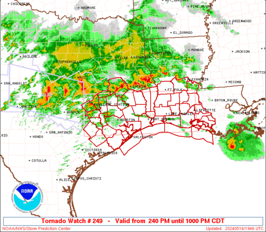
WW 249 TORNADO LA TX CW 161940Z – 170300Z URGENT – IMMEDIATE BROADCAST REQUESTED Tornado Watch Number 249 NWS Storm Prediction Center Norman OK 240 PM CDT Thu May 16 2024 The NWS Storm Prediction Center has issued a * Tornado Watch for portions of Southwest Louisiana Southeast Texas Coastal Waters * Effective this Thursday …
Continue reading SPC Tornado Watch 249
SPC Severe Thunderstorm Watch 250
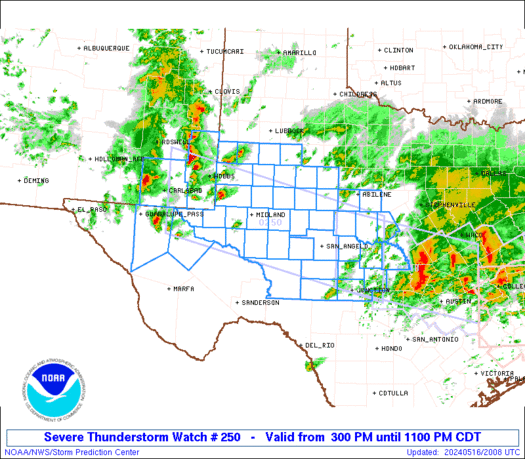
WW 250 SEVERE TSTM NM TX 162000Z – 170400Z URGENT – IMMEDIATE BROADCAST REQUESTED Severe Thunderstorm Watch Number 250 NWS Storm Prediction Center Norman OK 300 PM CDT Thu May 16 2024 The NWS Storm Prediction Center has issued a * Severe Thunderstorm Watch for portions of Southeast New Mexico West Texas into the Edwards …
Continue reading SPC Severe Thunderstorm Watch 250
SPC Day 3-8 Fire Weather Outlook

SPC Day 3-8 Fire Weather Outlook Day 3-8 Fire Weather Outlook NWS Storm Prediction Center Norman OK 0530 PM CDT Thu May 16 2024 Valid 181200Z – 241200Z By early this weekend a broad, longwave trough is expected over the far northern/northwestern CONUS with a subtropical jet continuing to progress east-northeastward from the Gulf Coast …
Continue reading SPC Day 3-8 Fire Weather Outlook
SPC MD 806
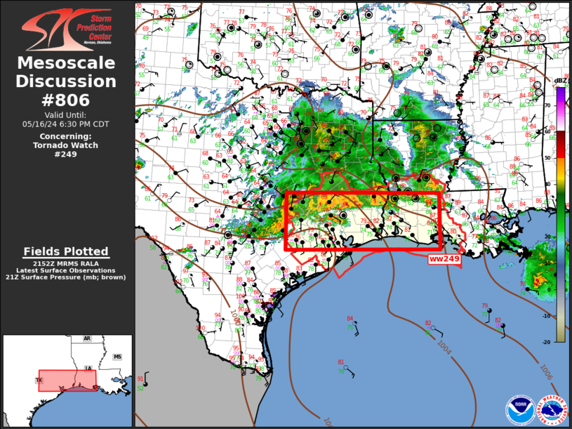
MD 0806 CONCERNING TORNADO WATCH 249… FOR SOUTHEAST TX…SOUTHERN LA Mesoscale Discussion 0806 NWS Storm Prediction Center Norman OK 0456 PM CDT Thu May 16 2024 Areas affected…Southeast TX…Southern LA Concerning…Tornado Watch 249… Valid 162156Z – 162330Z The severe weather threat for Tornado Watch 249 continues. SUMMARY…Severe threat will gradually spread southeast across ww249 this …
Continue reading SPC MD 806
SPC MD 805
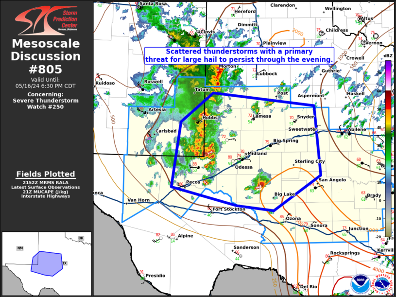
MD 0805 CONCERNING SEVERE THUNDERSTORM WATCH 250… FOR EASTERN NEW MEXICO INTO WEST TEXAS Mesoscale Discussion 0805 NWS Storm Prediction Center Norman OK 0455 PM CDT Thu May 16 2024 Areas affected…eastern New Mexico into West Texas Concerning…Severe Thunderstorm Watch 250… Valid 162155Z – 162330Z The severe weather threat for Severe Thunderstorm Watch 250 continues. …
Continue reading SPC MD 805
SPC MD 804
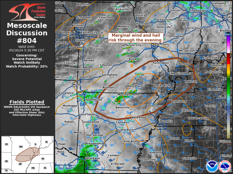
MD 0804 CONCERNING SEVERE POTENTIAL…WATCH UNLIKELY FOR NORTHERN ARKANSAS…SOUTH EASTERN MISSOURI…SOUTHERN ILLINOIS…FAR WESTERN KENTUCKY Mesoscale Discussion 0804 NWS Storm Prediction Center Norman OK 0325 PM CDT Thu May 16 2024 Areas affected…northern Arkansas…south eastern Missouri…southern Illinois…far western Kentucky Concerning…Severe potential…Watch unlikely Valid 162025Z – 162230Z Probability of Watch Issuance…20 percent SUMMARY…Marginal wind and hail risk …
Continue reading SPC MD 804
SPC May 16, 2024 2000 UTC Day 1 Convective Outlook

SPC 2000Z Day 1 Outlook Day 1 Convective Outlook NWS Storm Prediction Center Norman OK 0253 PM CDT Thu May 16 2024 Valid 162000Z – 171200Z …THERE IS AN ENHANCED RISK OF SEVERE THUNDERSTORMS IN SOUTHEAST TX AND SOUTHWEST LA… …SUMMARY… Scattered severe thunderstorms are expected into tonight across parts of Texas and Louisiana. The …
Continue reading SPC May 16, 2024 2000 UTC Day 1 Convective Outlook
SPC MD 803
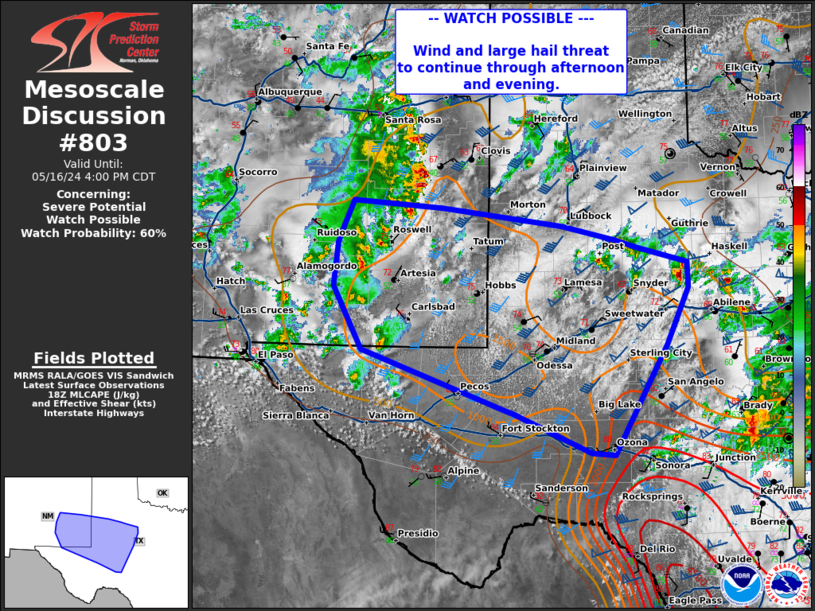
MD 0803 CONCERNING SEVERE POTENTIAL…WATCH POSSIBLE FOR WESTERN TEXAS Mesoscale Discussion 0803 NWS Storm Prediction Center Norman OK 0158 PM CDT Thu May 16 2024 Areas affected…western Texas Concerning…Severe potential…Watch possible Valid 161858Z – 162100Z Probability of Watch Issuance…60 percent SUMMARY…Threat of large hail and damaging wind to continue through the afternoon/evening. A watch will …
Continue reading SPC MD 803
SPC Day 2 Fire Weather Outlook

SPC Day 2 Fire Weather Outlook Day 2 Fire Weather Outlook NWS Storm Prediction Center Norman OK 0137 PM CDT Thu May 16 2024 Valid 171200Z – 181200Z …NO CRITICAL AREAS… …2000Z Update… A surface low will deepen in the lee of the northern Rockies over the High Plains of southeast Montana and northeast Wyoming …
Continue reading SPC Day 2 Fire Weather Outlook