

MD 2083 CONCERNING SEVERE POTENTIAL…WATCH UNLIKELY FOR PORTIONS OF EASTERN IOWA INTO CENTRAL MISSOURI…NORTHERN AND CENTRAL ARKANSAS…FAR SOUTHWESTERN TENNESSEE…FAR NORTHWESTERN MISSISSIPPI Mesoscale Discussion 2083 NWS Storm Prediction Center Norman OK 0449 PM CDT Mon Sep 15 2025 Areas affected…portions of eastern Iowa into central Missouri…northern and central Arkansas…far southwestern Tennessee…far northwestern Mississippi Concerning…Severe potential…Watch unlikely …
Continue reading SPC MD 2083
Category:Weather
SPC MD 2082
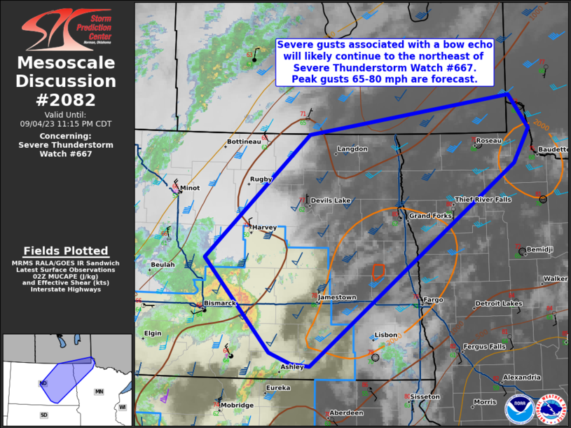
MD 2082 CONCERNING SEVERE POTENTIAL…WATCH UNLIKELY FOR MUCH OF WYOMING INTO FAR WESTERN SOUTH DAKOTA Mesoscale Discussion 2082 NWS Storm Prediction Center Norman OK 0433 PM CDT Mon Sep 15 2025 Areas affected…Much of Wyoming into far western South Dakota Concerning…Severe potential…Watch unlikely Valid 152133Z – 152330Z Probability of Watch Issuance…5 percent SUMMARY…A few severe …
Continue reading SPC MD 2082
SPC Severe Thunderstorm Watch 611 Status Reports

WW 0611 Status Updates STATUS REPORT ON WW 611 SEVERE WEATHER THREAT CONTINUES RIGHT OF A LINE FROM 30 NW RSL TO 10 ENE HSI. ..SPC..09/15/25 ATTN…WFO…GLD…GID…LBF… STATUS REPORT FOR WS 611 SEVERE WEATHER THREAT CONTINUES FOR THE FOLLOWING AREAS KSC141-163-183-150340- KS . KANSAS COUNTIES INCLUDED ARE OSBORNE ROOKS SMITH NEC001-035-081-129-181-150340- NE . NEBRASKA COUNTIES …
Continue reading SPC Severe Thunderstorm Watch 611 Status Reports
SPC MD 2081
MD 2081 CONCERNING TORNADO WATCH 610… FOR PORTIONS OF NORTHERN INTO EASTERN NORTH DAKOTA Mesoscale Discussion 2081 NWS Storm Prediction Center Norman OK 0658 PM CDT Sun Sep 14 2025 Areas affected…portions of northern into eastern North Dakota Concerning…Tornado Watch 610… Valid 142358Z – 150100Z The severe weather threat for Tornado Watch 610 continues. SUMMARY…A …
Continue reading SPC MD 2081
SPC Tornado Watch 610 Status Reports

WW 0610 Status Updates STATUS REPORT ON WW 610 SEVERE WEATHER THREAT CONTINUES RIGHT OF A LINE FROM 50 NE ABR TO 30 W JMS TO 55 NE BIS TO 15 SE MOT TO 60 N MOT. FOR ADDITIONAL INFORMATION SEE MESOSCALE DISCUSSION 2081 ..SQUITIERI..09/15/25 ATTN…WFO…FGF…BIS…ABR… STATUS REPORT FOR WT 610 SEVERE WEATHER THREAT CONTINUES …
Continue reading SPC Tornado Watch 610 Status Reports
SPC Tornado Watch 610
WW 610 TORNADO ND SD 141805Z – 150200Z URGENT – IMMEDIATE BROADCAST REQUESTED Tornado Watch Number 610 NWS Storm Prediction Center Norman OK 105 PM CDT Sun Sep 14 2025 The NWS Storm Prediction Center has issued a * Tornado Watch for portions of North Dakota Northern South Dakota * Effective this Sunday afternoon and …
Continue reading SPC Tornado Watch 610
SPC Severe Thunderstorm Watch 611
WW 611 SEVERE TSTM KS NE 142040Z – 150300Z URGENT – IMMEDIATE BROADCAST REQUESTED Severe Thunderstorm Watch Number 611 NWS Storm Prediction Center Norman OK 340 PM CDT Sun Sep 14 2025 The NWS Storm Prediction Center has issued a * Severe Thunderstorm Watch for portions of Northern Kansas Southwest and South-Central Nebraska * Effective …
Continue reading SPC Severe Thunderstorm Watch 611
SPC MD 2080

MD 2080 CONCERNING SEVERE THUNDERSTORM WATCH 611… FOR CENTRAL PLAINS Mesoscale Discussion 2080 NWS Storm Prediction Center Norman OK 0511 PM CDT Sun Sep 14 2025 Areas affected…Central Plains Concerning…Severe Thunderstorm Watch 611… Valid 142211Z – 150015Z The severe weather threat for Severe Thunderstorm Watch 611 continues. SUMMARY…Hail/wind threat continues with storms over the central …
Continue reading SPC MD 2080
SPC MD 2079

MD 2079 CONCERNING TORNADO WATCH 610… FOR PORTIONS OF CENTRAL INTO EASTERN NORTH DAKOTA Mesoscale Discussion 2079 NWS Storm Prediction Center Norman OK 0509 PM CDT Sun Sep 14 2025 Areas affected…portions of central into eastern North Dakota Concerning…Tornado Watch 610… Valid 142209Z – 142345Z The severe weather threat for Tornado Watch 610 continues. SUMMARY…Tornadoes …
Continue reading SPC MD 2079
SPC MD 2078
MD 2078 CONCERNING TORNADO WATCH 610… FOR CENTRAL NORTH DAKOTA Mesoscale Discussion 2078 NWS Storm Prediction Center Norman OK 0347 PM CDT Sun Sep 14 2025 Areas affected…central North Dakota Concerning…Tornado Watch 610… Valid 142047Z – 142215Z The severe weather threat for Tornado Watch 610 continues. SUMMARY…Tornado risk continues within WW610. DISCUSSION…Several tornadoes have been …
Continue reading SPC MD 2078