
WW 0038 Status Updates STATUS REPORT ON WW 38 SEVERE WEATHER THREAT CONTINUES RIGHT OF A LINE FROM 35 N PIB TO 35 S GLH TO 10 N ELD TO 25 E DEQ. ..MOORE..03/15/25 ATTN…WFO…LZK…JAN…SHV… STATUS REPORT FOR WT 38 SEVERE WEATHER THREAT CONTINUES FOR THE FOLLOWING AREAS ARC001-003-011-013-017-025-039-041-043-069-079-103-150840- AR . ARKANSAS COUNTIES INCLUDED ARE …
Continue reading SPC Tornado Watch 38 Status Reports
Category:Weather
SPC Tornado Watch 37 Status Reports
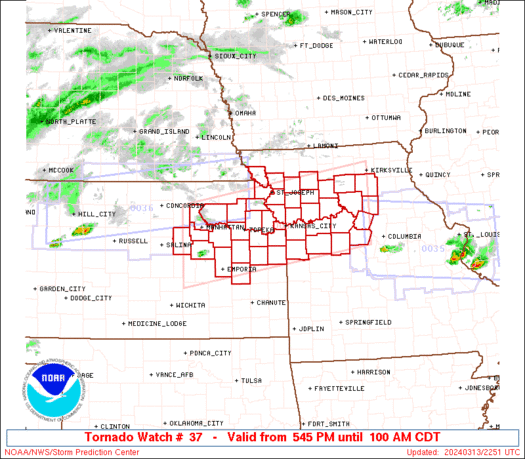
WW 0037 Status Updates STATUS REPORT ON WW 37 SEVERE WEATHER THREAT CONTINUES RIGHT OF A LINE FROM 35 NNW EVV TO 10 S HUF TO 20 NNE HUF TO 25 NNW LAF. ..MOORE..03/15/25 ATTN…WFO…LSX…ILX…LOT…IND… STATUS REPORT FOR WT 37 SEVERE WEATHER THREAT CONTINUES FOR THE FOLLOWING AREAS INC021-027-055-083-101-107-119-133-153-157-150840- IN . INDIANA COUNTIES INCLUDED ARE …
Continue reading SPC Tornado Watch 37 Status Reports
SPC Tornado Watch 42
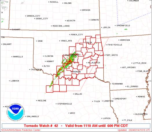
WW 42 TORNADO AL TN 150735Z – 151500Z URGENT – IMMEDIATE BROADCAST REQUESTED Tornado Watch Number 42 NWS Storm Prediction Center Norman OK 235 AM CDT Sat Mar 15 2025 The NWS Storm Prediction Center has issued a * Tornado Watch for portions of Western and Northern Alabama Southern Middle Tennessee * Effective this Saturday …
Continue reading SPC Tornado Watch 42
SPC Tornado Watch 41
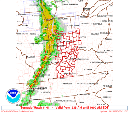
WW 41 TORNADO IN KY OH 150635Z – 151400Z URGENT – IMMEDIATE BROADCAST REQUESTED Tornado Watch Number 41 NWS Storm Prediction Center Norman OK 235 AM EDT Sat Mar 15 2025 The NWS Storm Prediction Center has issued a * Tornado Watch for portions of Central and Southern Indiana Central Kentucky Western Ohio * Effective …
Continue reading SPC Tornado Watch 41
SPC Severe Thunderstorm Watch 39 Status Reports
WW 0039 Status Updates STATUS REPORT ON WW 39 SEVERE WEATHER THREAT CONTINUES RIGHT OF A LINE FROM 20 ENE RFD TO 20 SE MSN TO 40 NNW MSN. ..GOSS..03/15/25 ATTN…WFO…MKX… STATUS REPORT FOR WS 39 SEVERE WEATHER THREAT CONTINUES FOR THE FOLLOWING AREAS WIC021-027-055-059-079-089-101-127-131-133-150640- WI . WISCONSIN COUNTIES INCLUDED ARE COLUMBIA DODGE JEFFERSON KENOSHA …
Continue reading SPC Severe Thunderstorm Watch 39 Status Reports
SPC Severe Thunderstorm Watch 40
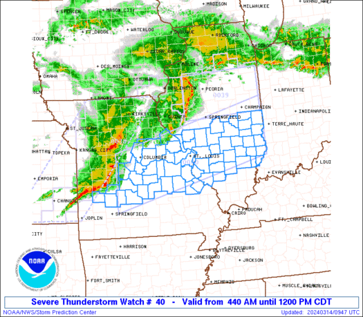
WW 40 SEVERE TSTM IN MI OH LM 150515Z – 151300Z URGENT – IMMEDIATE BROADCAST REQUESTED Severe Thunderstorm Watch Number 40 NWS Storm Prediction Center Norman OK 115 AM EDT Sat Mar 15 2025 The NWS Storm Prediction Center has issued a * Severe Thunderstorm Watch for portions of Northern Indiana Far Southern Michigan Far …
Continue reading SPC Severe Thunderstorm Watch 40
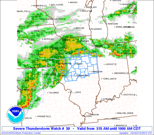
SPC Severe Thunderstorm Watch 39
WW 39 SEVERE TSTM WI 150305Z – 150900Z URGENT – IMMEDIATE BROADCAST REQUESTED Severe Thunderstorm Watch Number 39 NWS Storm Prediction Center Norman OK 1005 PM CDT Fri Mar 14 2025 The NWS Storm Prediction Center has issued a * Severe Thunderstorm Watch for portions of Southern Wisconsin * Effective this Friday night and Saturday …
Continue reading SPC Severe Thunderstorm Watch 39
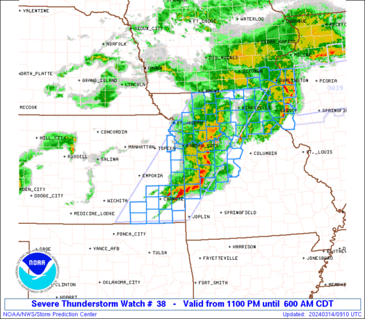
SPC Tornado Watch 38
WW 38 TORNADO AR LA MS 150245Z – 151000Z URGENT – IMMEDIATE BROADCAST REQUESTED Tornado Watch Number 38 NWS Storm Prediction Center Norman OK 945 PM CDT Fri Mar 14 2025 The NWS Storm Prediction Center has issued a * Tornado Watch for portions of Southern Arkansas Northeast Louisiana Western Mississippi * Effective this Friday …
Continue reading SPC Tornado Watch 38
SPC Severe Thunderstorm Watch 35 Status Reports

WW 0035 Status Updates STATUS REPORT ON WW 35 THE SEVERE WEATHER THREAT CONTINUES ACROSS THE ENTIRE WATCH AREA. ..GOSS..03/15/25 ATTN…WFO…DVN…LOT… STATUS REPORT FOR WS 35 SEVERE WEATHER THREAT CONTINUES FOR THE FOLLOWING AREAS ILC007-011-015-031-037-043-063-067-071-073-085-089-091-093-097- 099-103-109-111-131-141-155-161-177-187-195-197-201-150240- IL . ILLINOIS COUNTIES INCLUDED ARE BOONE BUREAU CARROLL COOK DE KALB DUPAGE GRUNDY HANCOCK HENDERSON HENRY JO DAVIESS …
Continue reading SPC Severe Thunderstorm Watch 35 Status Reports
SPC Severe Thunderstorm Watch 34 Status Reports
WW 0034 Status Updates STATUS REPORT ON WW 34 SEVERE WEATHER THREAT CONTINUES RIGHT OF A LINE FROM 30 SSW MCW TO 35 W MCW TO 35 NE OTG. ..GOSS..03/15/25 ATTN…WFO…ARX…FSD…DMX…MPX… STATUS REPORT FOR WS 34 SEVERE WEATHER THREAT CONTINUES FOR THE FOLLOWING AREAS IAC005-033-037-043-065-067-081-089-131-189-191-195-150240- IA . IOWA COUNTIES INCLUDED ARE ALLAMAKEE CERRO GORDO CHICKASAW …
Continue reading SPC Severe Thunderstorm Watch 34 Status Reports