
WW 27 SEVERE TSTM MD VA CW 051525Z – 052300Z URGENT – IMMEDIATE BROADCAST REQUESTED Severe Thunderstorm Watch Number 27 NWS Storm Prediction Center Norman OK 1025 AM EST Wed Mar 5 2025 The NWS Storm Prediction Center has issued a * Severe Thunderstorm Watch for portions of Southern Maryland Eastern/Southeastern Virginia Coastal Waters * …
Continue reading SPC Severe Thunderstorm Watch 27
Category:Weather
SPC MD 148

MD 0148 CONCERNING SEVERE POTENTIAL…WATCH UNLIKELY FOR CENTRAL AND NORTHERN FLORIDA Mesoscale Discussion 0148 NWS Storm Prediction Center Norman OK 0841 AM CST Wed Mar 05 2025 Areas affected…central and northern Florida Concerning…Severe potential…Watch unlikely Valid 051441Z – 051615Z Probability of Watch Issuance…20 percent SUMMARY…Isolated damaging wind gusts are possible through early afternoon across central …
Continue reading SPC MD 148
SPC Severe Thunderstorm Watch 25 Status Reports

WW 0025 Status Updates STATUS REPORT ON WW 25 SEVERE WEATHER THREAT CONTINUES RIGHT OF A LINE FROM 25 NE CTY TO 35 SSE AYS TO 35 ENE AYS TO 30 WSW SAV TO 30 SSW OGB TO 30 SSW OGB. ..BENTLEY..03/05/25 ATTN…WFO…JAX…TAE…FFC…CHS… STATUS REPORT FOR WS 25 SEVERE WEATHER THREAT CONTINUES FOR THE FOLLOWING …
Continue reading SPC Severe Thunderstorm Watch 25 Status Reports
SPC MD 147

MD 0147 CONCERNING SEVERE POTENTIAL…WATCH POSSIBLE FOR SOUTH-CENTRAL VIRGINIA Mesoscale Discussion 0147 NWS Storm Prediction Center Norman OK 0750 AM CST Wed Mar 05 2025 Areas affected…south-central Virginia Concerning…Severe potential…Watch possible Valid 051350Z – 051545Z Probability of Watch Issuance…60 percent SUMMARY…A risk of damaging gusts or a brief tornado will gradually increase across parts of …
Continue reading SPC MD 147
SPC MD 146

MD 0146 CONCERNING SEVERE POTENTIAL…WATCH LIKELY FOR MUCH OF CENTRAL SOUTH AND NORTH CAROLINA Mesoscale Discussion 0146 NWS Storm Prediction Center Norman OK 0622 AM CST Wed Mar 05 2025 Areas affected…much of central South and North Carolina Concerning…Severe potential…Watch likely Valid 051222Z – 051445Z Probability of Watch Issuance…80 percent SUMMARY…The environment is beginning to …
Continue reading SPC MD 146
SPC Tornado Watch 26
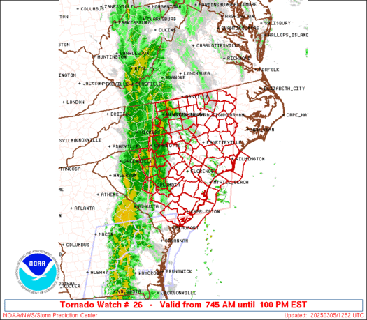
WW 26 TORNADO NC SC CW 051245Z – 051800Z URGENT – IMMEDIATE BROADCAST REQUESTED Tornado Watch Number 26 NWS Storm Prediction Center Norman OK 745 AM EST Wed Mar 5 2025 The NWS Storm Prediction Center has issued a * Tornado Watch for portions of Central and Eastern North Carolina Central and Eastern South Carolina …
Continue reading SPC Tornado Watch 26
SPC Tornado Watch 24 Status Reports

WW 0024 Status Updates STATUS REPORT ON WW 24 SEVERE WEATHER THREAT CONTINUES RIGHT OF A LINE FROM 50 SW AAF TO 20 WNW AAF TO 35 WSW TLH TO 20 NW TLH TO 25 W MGR TO 10 E ABY TO 30 NE ABY. ..JEWELL..03/05/25 ATTN…WFO…TAE… STATUS REPORT FOR WT 24 SEVERE WEATHER THREAT …
Continue reading SPC Tornado Watch 24 Status Reports
SPC MD 145

MD 0145 CONCERNING TORNADO WATCH 24… FOR FLORIDA PANHANDLE INTO PARTS OF CENTRAL TO SOUTHERN GEORGIA Mesoscale Discussion 0145 NWS Storm Prediction Center Norman OK 0135 AM CST Wed Mar 05 2025 Areas affected…Florida Panhandle into parts of central to southern Georgia Concerning…Tornado Watch 24… Valid 050735Z – 051100Z The severe weather threat for Tornado …
Continue reading SPC MD 145
SPC Severe Thunderstorm Watch 25
WW 25 SEVERE TSTM FL GA SC CW 050815Z – 051500Z URGENT – IMMEDIATE BROADCAST REQUESTED Severe Thunderstorm Watch Number 25 NWS Storm Prediction Center Norman OK 315 AM EST Wed Mar 5 2025 The NWS Storm Prediction Center has issued a * Severe Thunderstorm Watch for portions of North Florida Southern into Southeast Georgia …
Continue reading SPC Severe Thunderstorm Watch 25
SPC MD 144

MD 0144 CONCERNING SEVERE THUNDERSTORM WATCH 23… FOR FAR EASTERN ALABAMA AND NORTHWESTERN GEORGIA Mesoscale Discussion 0144 NWS Storm Prediction Center Norman OK 1136 PM CST Tue Mar 04 2025 Areas affected…Far eastern Alabama and northwestern Georgia Concerning…Severe Thunderstorm Watch 23… Valid 050536Z – 050730Z The severe weather threat for Severe Thunderstorm Watch 23 continues. …
Continue reading SPC MD 144