

MD 0102 CONCERNING TORNADO WATCH 9… FOR MIDDLE TENNESSEE AND SOUTHERN KENTUCKY Mesoscale Discussion 0102 NWS Storm Prediction Center Norman OK 0913 PM CST Sat Feb 15 2025 Areas affected…Middle Tennessee and Southern Kentucky Concerning…Tornado Watch 9… Valid 160313Z – 160415Z The severe weather threat for Tornado Watch 9 continues. SUMMARY…Severe threat continues within WW009. …
Continue reading SPC MD 102
Category:Weather
SPC MD 101

MD 0101 CONCERNING SEVERE POTENTIAL…WATCH LIKELY FOR CENTRAL GULF STATES Mesoscale Discussion 0101 NWS Storm Prediction Center Norman OK 0837 PM CST Sat Feb 15 2025 Areas affected…Central Gulf States Concerning…Severe potential…Watch likely Valid 160237Z – 160330Z Probability of Watch Issuance…95 percent SUMMARY…New Tornado Watch will be issued across the central Gulf States by 0330z. …
Continue reading SPC MD 101
SPC Tornado Watch 10
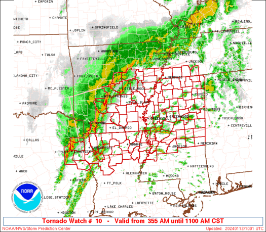
WW 10 TORNADO AL FL LA MS TN CW 160310Z – 161000Z URGENT – IMMEDIATE BROADCAST REQUESTED Tornado Watch Number 10 NWS Storm Prediction Center Norman OK 910 PM CST Sat Feb 15 2025 The NWS Storm Prediction Center has issued a * Tornado Watch for portions of Much of Alabama Western Florida Panhandle Southeast …
Continue reading SPC Tornado Watch 10
SPC Tornado Watch 9
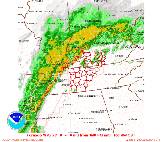
WW 9 TORNADO KY TN 160040Z – 160700Z URGENT – IMMEDIATE BROADCAST REQUESTED Tornado Watch Number 9 NWS Storm Prediction Center Norman OK 640 PM CST Sat Feb 15 2025 The NWS Storm Prediction Center has issued a * Tornado Watch for portions of South Central Kentucky Middle Tennessee * Effective this Saturday night and …
Continue reading SPC Tornado Watch 9
SPC MD 100
MD 0100 CONCERNING TORNADO WATCH 8… FOR WESTERN TENNESSEE AND SOUTHWESTERN KENTUCKY Mesoscale Discussion 0100 NWS Storm Prediction Center Norman OK 0609 PM CST Sat Feb 15 2025 Areas affected…western Tennessee and southwestern Kentucky Concerning…Tornado Watch 8… Valid 160009Z – 160145Z The severe weather threat for Tornado Watch 8 continues. SUMMARY…Tornado threat continues within WW008. …
Continue reading SPC MD 100
SPC MD 99

MD 0099 CONCERNING TORNADO WATCH 8… FOR LOWER MISSISSIPPI VALLEY Mesoscale Discussion 0099 NWS Storm Prediction Center Norman OK 0549 PM CST Sat Feb 15 2025 Areas affected…Lower Mississippi Valley Concerning…Tornado Watch 8… Valid 152349Z – 160115Z The severe weather threat for Tornado Watch 8 continues. SUMMARY…Pre-frontal supercells may mature over the next few hours …
Continue reading SPC MD 99
SPC Tornado Watch 8
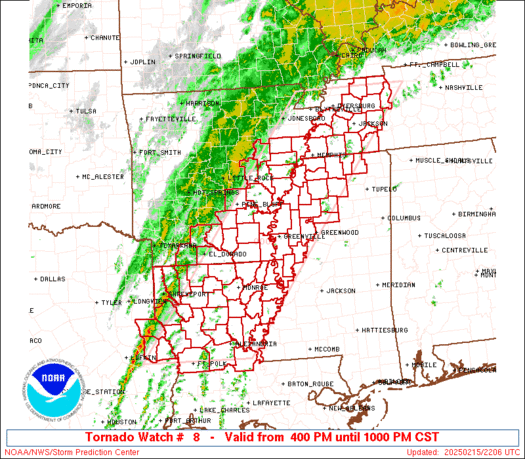
WW 8 TORNADO AR LA MS TN TX 152200Z – 160400Z URGENT – IMMEDIATE BROADCAST REQUESTED Tornado Watch Number 8 NWS Storm Prediction Center Norman OK 400 PM CST Sat Feb 15 2025 The NWS Storm Prediction Center has issued a * Tornado Watch for portions of Eastern and Southeast Arkansas Northern and Central Louisiana …
Continue reading SPC Tornado Watch 8
SPC MD 98

MD 0098 CONCERNING SEVERE POTENTIAL…WATCH LIKELY FOR PARTS OF SOUTHERN AND EASTERN ARKANSAS AND ADJACENT PORTIONS OF NORTHWESTERN LOUISIANA…NORTHWESTERN MISSISSIPPI AND WESTERN TENNESSEE Mesoscale Discussion 0098 NWS Storm Prediction Center Norman OK 0106 PM CST Sat Feb 15 2025 Areas affected…parts of southern and eastern Arkansas and adjacent portions of northwestern Louisiana…northwestern Mississippi and western …
Continue reading SPC MD 98
SPC MD 97
MD 0097 CONCERNING FREEZING RAIN FOR PARTS OF SOUTHERN PENNSYLVANIA AND NORTHWEST MARYLAND Mesoscale Discussion 0097 NWS Storm Prediction Center Norman OK 1150 AM CST Sat Feb 15 2025 Areas affected…parts of southern Pennsylvania and northwest Maryland Concerning…Freezing rain Valid 151750Z – 152145Z SUMMARY…Freezing rain is expected with ice accretion of 0.05″ to 0.1″ is …
Continue reading SPC MD 97
SPC MD 96

MD 0096 CONCERNING SEVERE POTENTIAL…WATCH UNLIKELY FOR THE SACRAMENTO AND SAN JOAQUIN VALLEYS IN CENTRAL CALIFORNIA Mesoscale Discussion 0096 NWS Storm Prediction Center Norman OK 0246 PM CST Thu Feb 13 2025 Areas affected…The Sacramento and San Joaquin Valleys in central California Concerning…Severe potential…Watch unlikely Valid 132046Z – 132245Z Probability of Watch Issuance…5 percent SUMMARY…Sporadic …
Continue reading SPC MD 96