

MD 0037 CONCERNING SEVERE POTENTIAL…WATCH UNLIKELY FOR PORTIONS OF NORTH AND WEST-CENTRAL FLORIDA Mesoscale Discussion 0037 NWS Storm Prediction Center Norman OK 0632 AM CST Sun Jan 19 2025 Areas affected…Portions of North and west-central Florida Concerning…Severe potential…Watch unlikely Valid 191232Z – 191430Z Probability of Watch Issuance…20 percent SUMMARY…Damaging wind gusts and perhaps a brief …
Continue reading SPC MD 37
Category:Weather
SPC MD 36

MD 0036 CONCERNING SEVERE POTENTIAL…WATCH UNLIKELY FOR PORTIONS OF WESTERN NORTH FLORIDA Mesoscale Discussion 0036 NWS Storm Prediction Center Norman OK 0108 AM CST Sun Jan 19 2025 Areas affected…Portions of western North Florida Concerning…Severe potential…Watch unlikely Valid 190708Z – 190915Z Probability of Watch Issuance…20 percent SUMMARY…Strong wind gusts and perhaps a brief tornado are …
Continue reading SPC MD 36
SPC MD 35

MD 0035 CONCERNING SNOW SQUALL FOR SOUTH-CENTRAL NEW YORK INTO FAR NORTHERN PENNSYLVANIA Mesoscale Discussion 0035 NWS Storm Prediction Center Norman OK 1245 PM CST Mon Jan 13 2025 Areas affected…south-central New York into far northern Pennsylvania Concerning…Snow Squall Valid 131845Z – 132045Z SUMMARY…Snow squall activity will be possible through the afternoon diminishing through the …
Continue reading SPC MD 35
SPC MD 34

MD 0034 CONCERNING FREEZING RAIN FOR CENTRAL AND EASTERN PORTIONS OF THE CAROLINAS Mesoscale Discussion 0034 NWS Storm Prediction Center Norman OK 0927 PM CST Fri Jan 10 2025 Areas affected…central and eastern portions of the Carolinas Concerning…Freezing rain Valid 110327Z – 110600Z SUMMARY…Freezing rain will continue into tonight. The heaviest ice accretion rates will …
Continue reading SPC MD 34
SPC MD 33

MD 0033 CONCERNING FREEZING RAIN FOR PORTIONS OF CENTRAL AND NORTHERN SOUTH CAROLINA INTO CENTRAL NORTH CAROLINA Mesoscale Discussion 0033 NWS Storm Prediction Center Norman OK 0534 PM CST Fri Jan 10 2025 Areas affected…portions of central and northern South Carolina into central North Carolina Concerning…Freezing rain Valid 102334Z – 110330Z SUMMARY…Heavier freezing rain rates …
Continue reading SPC MD 33
SPC MD 32
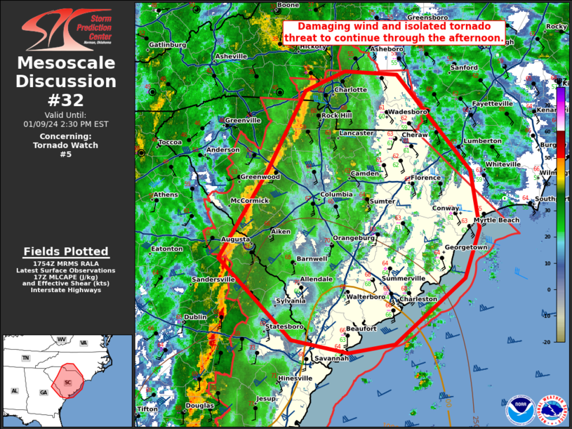
MD 0032 CONCERNING WINTER MIXED PRECIPITATION FOR NORTHERN GEORGIA…EASTERN TENNESSEE…FAR WESTERN SOUTH CAROLINA…WESTERN NORTH CAROLINA Mesoscale Discussion 0032 NWS Storm Prediction Center Norman OK 0330 PM CST Fri Jan 10 2025 Areas affected…northern Georgia…eastern Tennessee…far western South Carolina…western North Carolina Concerning…Winter mixed precipitation Valid 102130Z – 110030Z SUMMARY…Areas of moderate to heavy snowfall along the …
Continue reading SPC MD 32
SPC MD 31
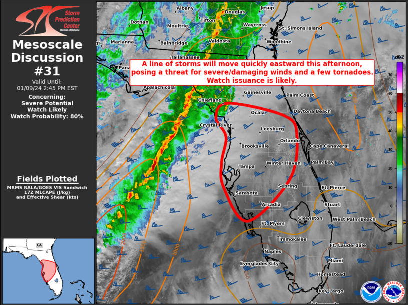
MD 0031 CONCERNING WINTER MIXED PRECIPITATION FOR NORTHEAST GA INTO PARTS OF SC Mesoscale Discussion 0031 NWS Storm Prediction Center Norman OK 0750 AM CST Fri Jan 10 2025 Areas affected…Northeast GA into parts of SC Concerning…Winter mixed precipitation Valid 101350Z – 101745Z SUMMARY…Winter mixed precipitation may increase through the morning. DISCUSSION…The eastern portion of …
Continue reading SPC MD 31
SPC MD 30

MD 0030 CONCERNING WINTER MIXED PRECIPITATION FOR PARTS OF NORTHEAST MS…NORTHERN AL/GA…SOUTHERN MIDDLE TN Mesoscale Discussion 0030 NWS Storm Prediction Center Norman OK 0419 AM CST Fri Jan 10 2025 Areas affected…Parts of northeast MS…northern AL/GA…southern middle TN Concerning…Winter mixed precipitation Valid 101019Z – 101515Z SUMMARY…An increase in winter precipitation rates is possible through the …
Continue reading SPC MD 30
SPC MD 29

MD 0029 CONCERNING HEAVY SNOW FOR CENTRAL/NORTHERN AR INTO NORTHERN MS AND WESTERN TN Mesoscale Discussion 0029 NWS Storm Prediction Center Norman OK 0242 AM CST Fri Jan 10 2025 Areas affected…Central/northern AR into northern MS and western TN Concerning…Heavy snow Valid 100842Z – 101345Z SUMMARY…Occasional snow rates of near/above 1 inch per hour remain …
Continue reading SPC MD 29
SPC MD 28

MD 0028 CONCERNING FREEZING RAIN FOR PORTIONS OF CENTRAL INTO SOUTHERN ARKANSAS AND NORTHERN MISSISSIPPI Mesoscale Discussion 0028 NWS Storm Prediction Center Norman OK 1003 PM CST Thu Jan 09 2025 Areas affected…portions of central into southern Arkansas and northern Mississippi Concerning…Freezing rain Valid 100403Z – 100900Z SUMMARY…Freezing rain should continue across central and southern …
Continue reading SPC MD 28