
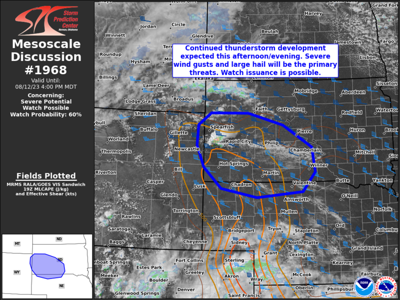
MD 1968 CONCERNING SEVERE POTENTIAL…WATCH POSSIBLE FOR WEST-CENTRAL SD AND THE VICINITY
Mesoscale Discussion 1968
NWS Storm Prediction Center Norman OK
0256 PM CDT Sat Aug 12 2023
Areas affected…west-central SD and the vicinity
Concerning…Severe potential…Watch possible
Valid 121956Z – 122200Z
Probability of Watch Issuance…60 percent
SUMMARY…Continued thunderstorm development is expected this
afternoon/evening. Severe wind gusts and large hail will be the
primary threats. Watch issuance is possible.
DISCUSSION…Convective development is underway near the Black Hills
northward through northwestern SD. These thunderstorms are located
to the northeast of a surface low — centered over eastern WY — at
the periphery of a low-level warm, moist axis extending northward
through western NE and SD. A belt of west-southwesterlies aloft
overspreads the northern Plains, with 30-35 kt 500-mb flow currently
analyzed over west-central SD. Large-scale ascent in the
right-entrance region of this mid-level jet, as well as enhanced
surface convergence to the northeast of the surface cyclone, are
expected to support continued updraft development and
intensification this afternoon in the delineated area.
The richest low-level moisture resides to the south, with 60s-F
dewpoints reaching to around the SD/NE border. However, temperatures
in the lower 80s F and dewpoints generally in the mid-50s F are
contributing to MLCAPE around 1000-1500 J/kg in southwest SD.
Continued diurnal heating into the mid-80s F should promote
sufficiently deep boundary-layer mixing to erode remaining
inhibition and support thunderstorm development. Forecast profiles
depict rather dry air near the top of the boundary layer and at
mid-levels, suggesting realized updraft buoyancy will be tempered
somewhat by entrainment. However, straight hodographs with 0-6-km
shear around 40 kts should be sufficient to support supercell
development with successful initiation attempts. The shear profile
will favor updraft splitting early in individual storms’ lifecycles,
with both flanks offering a threat for severe wind gusts and large
hail. Given relatively dry boundary layers and weak low-level shear,
individual supercells/clusters should grow upscale by the evening,
yielding more of a severe-wind threat thereafter. A Severe
Thunderstorm Watch will likely be needed sometime this afternoon to
address these threats.
..Flournoy/Smith.. 08/12/2023
…Please see www.spc.noaa.gov for graphic product…
ATTN…WFO…ABR…LBF…UNR…CYS…
LAT…LON 43410404 44060433 44640428 44990378 44990227 44650087
43999973 43289960 42700011 42550193 42800335 43410404