
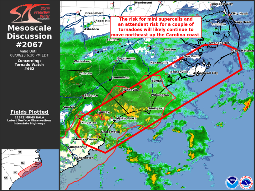
MD 2067 CONCERNING TORNADO WATCH 662… FOR PORTIONS OF THE CAROLINA COAST
Mesoscale Discussion 2067
NWS Storm Prediction Center Norman OK
0436 PM CDT Wed Aug 30 2023
Areas affected…portions of the Carolina coast
Concerning…Tornado Watch 662…
Valid 302136Z – 302230Z
The severe weather threat for Tornado Watch 662 continues.
SUMMARY…The risk for mini supercells and an attendant risk for a
couple of tornadoes will likely continue to move northeast up the
Carolina coast through the evening. A tornado watch will be
considered to include portions of the Outer Banks to the northeast
of the Tornado Watch #662 when the environment becomes more
favorable for tornadoes.
DISCUSSION…Late afternoon radar imagery from KLTX (Wilmington, NC)
shows a cluster of quasi-discrete supercells near the northeast SC
coast/Grand Strand vicinity and adjacent continental shelf waters
south of Cape Fear. A significant increase in low-level shear has
been observed at KLTX during the past 2 hours with 0-1 km SRH (using
observed storm motion) in excess of 400 m2/s2. With a nearly
saturated profile and mid 70s surface dewpoints, only weak buoyancy
is analyzed. However, the strengthening low-level shear profiles
and enlarging hodographs will continue to be favorable for low-level
mesocyclones over the next few hours as the outer bands of Idalia
continue northeastward up the coast. The area of favorable
shear/buoyancy will probably overspread portions of the Outer Banks
later this evening.
..Smith/Grams.. 08/30/2023
…Please see www.spc.noaa.gov for graphic product…
ATTN…WFO…MHX…RAH…ILM…CHS…
LAT…LON 33427996 33767980 35397647 35447595 35287554 34847542
32957915 33147971 33427996