
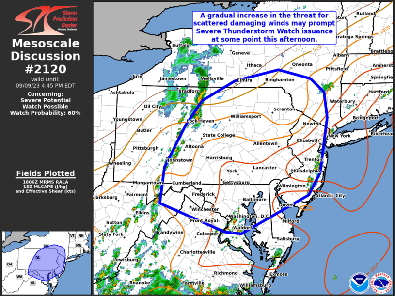
MD 2120 CONCERNING SEVERE POTENTIAL…WATCH POSSIBLE FOR PORTIONS OF THE MID-ATLANTIC
Mesoscale Discussion 2120
NWS Storm Prediction Center Norman OK
0108 PM CDT Sat Sep 09 2023
Areas affected…Portions of the Mid-Atlantic
Concerning…Severe potential…Watch possible
Valid 091808Z – 092045Z
Probability of Watch Issuance…60 percent
SUMMARY…A gradual increase in the threat for scattered wind damage
may prompt Severe Thunderstorm Watch issuance at some point this
afternoon.
DISCUSSION…Recent visible satellite and radar imagery show a well
defined MCV present over northwestern PA and far southwestern NY,
moving slowly northeastward. A diffuse surface boundary is present
to the east of the MCV across parts of southern NY into central PA
and MD. Persistent cloud cover along/north of this boundary has
hampered daytime heating to some extent, and a zone of differential
heating exists from roughly the higher terrain of the Appalachians
in central PA into far southern NY. Aided by modest ascent attendant
to the MCV, thunderstorms have already developed across parts of
central PA. Separate areas of convection are also ongoing across
parts of northern VA/southern MD, and over eastern NJ in association
with a sea breeze.
The 12Z IAD observed sounding showed generally modest lapse rates
aloft, but latest surface observations indicate that a fairly moist
low-level airmass exists across much of the Mid-Atlantic along/east
of the weak surface boundary. Where area of clearing have occurred,
MLCAPE has already increased to around 1500-2500 J/kg. Additional
heating through the rest of the afternoon may support modest
additional increases in boundary-layer instability. Away from the
mid-level MCV circulation, flow remains modest through much of the
troposphere. Closer to the circulation, namely central PA into
south-central NY, around 30-35 kt of southwesterly mid-level flow is
fostering similar values of deep-layer shear. A mix of multicells
and occasional supercells may develop and spread northeastward
across these areas through the afternoon/evening.
Scattered damaging winds should be the main threat, especially where
low-level lapse rates have been steepened by greater diurnal
heating. But, isolated large hail may also occur with the more
cellular convection. Thunderstorms across VA/MD/DE/NJ will probably
tend to be less organized given weaker deep-layer shear, but
isolated damaging winds still appear possible with downbursts given
a favorable thermodynamic environment with ample DCAPE (900-1000
J/kg or greater). At some point this afternoon, a Severe
Thunderstorm Watch may be needed for parts of the Mid-Atlantic,
especially if convection near the MCV begins to show signs of
clustering or supercellular characteristics.
..Gleason/Guyer.. 09/09/2023
…Please see www.spc.noaa.gov for graphic product…
ATTN…WFO…OKX…ALY…PHI…BGM…CTP…LWX…
LAT…LON 40097897 41107834 41677785 42157684 42417546 42187445
41867403 41277396 39977421 39467457 38567662 38607712
39257909 40097897