
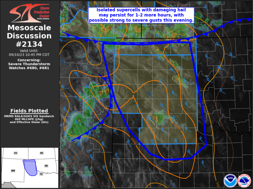
MD 2134 CONCERNING SEVERE THUNDERSTORM WATCH 680…681… FOR SOUTHWEST KANSAS…OKLAHOMA AND TEXAS PANHANDLES
Mesoscale Discussion 2134
NWS Storm Prediction Center Norman OK
0740 PM CDT Sun Sep 10 2023
Areas affected…southwest Kansas…Oklahoma and Texas Panhandles
Concerning…Severe Thunderstorm Watch 680…681…
Valid 110040Z – 110345Z
The severe weather threat for Severe Thunderstorm Watch 680, 681
continues.
SUMMARY…Isolated storms will continue to pose a large-hail threat
this evening, with areas of strong outflow and locally damaging
gusts.
DISCUSSION…A cold front continues to move southward across
southeast CO into southwest KS, reinforced by outflow from storms
oriented roughly along the 37th parallel. Other isolated cells were
located well ahead of the front and within the instability plume
extending southward across the TX Panhandle and northern South
Plains. The 00Z sounding from AMA shows little convective
inhibition, with steep lapse rates aloft. Winds veer with height,
but are generally at or below 20 kt in magnitude below 500 mb.
Still, the west/northwest flow regime aloft will continue to favor
south/southeastward-moving storms.
Isolated cells ahead of the cold front may pose a hail threat until
an hour or two after sunset, while outflows with the frontal
activity and storms over eastern NM congeal. Strong wind gusts will
be likely as a result given such a scenario, with potential for a
few severe gusts.
..Jewell.. 09/11/2023
…Please see www.spc.noaa.gov for graphic product…
ATTN…WFO…OUN…LUB…AMA…ABQ…
LAT…LON 34250246 35120297 35650315 36580346 36830345 36820292
36800200 36880086 36860023 36160009 34789979 33789969
33390026 33350115 33530168 34250246