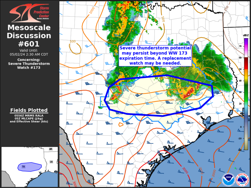
MD 0601 CONCERNING SEVERE THUNDERSTORM WATCH 173… FOR PORTIONS OF CENTRAL INTO SOUTHEAST TEXAS
Mesoscale Discussion 0601
NWS Storm Prediction Center Norman OK
1258 AM CDT Thu May 02 2024
Areas affected…portions of central into southeast Texas
Concerning…Severe Thunderstorm Watch 173…
Valid 020558Z – 020730Z
The severe weather threat for Severe Thunderstorm Watch 173
continues.
SUMMARY…Damaging-wind potential may persist beyond the 07z
expiration time of Severe Thunderstorm Watch 173. A replacement
watch may be needed.
DISCUSSION…A small but strong bowing segment from Llano into
Gillespie Counties in the central TX continues to be well-organized
per regional radar. Meanwhile, further to the east, a cluster of
strong to severe thunderstorms is ongoing north of Houston. Both of
these areas of convection are persisting along a west-to-east
oriented instability gradient, and within a 40-50 kt southerly
low-level jet. This should aid in continued storm organization and
at least some risk for damaging gusts the next few hours. With
Severe Thunderstorm Watch 173 set to expire at 07z, a replacement
watch may be needed if current trends persist over the next 30
minutes or so.
..Leitman.. 05/02/2024
…Please see www.spc.noaa.gov for graphic product…
ATTN…WFO…LCH…HGX…FWD…EWX…SJT…
LAT…LON 31149849 31309648 30899459 30519457 30099511 29819668
29889817 30039890 30379913 30839896 31149849
