
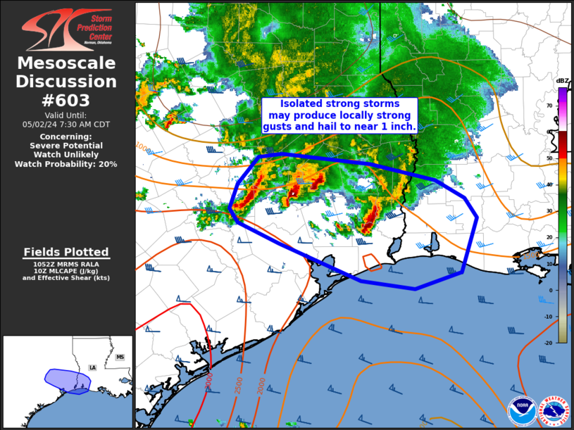
MD 0603 CONCERNING SEVERE POTENTIAL…WATCH UNLIKELY FOR SOUTHEAST TEXAS INTO SOUTHWEST LOUISIANA
Mesoscale Discussion 0603
NWS Storm Prediction Center Norman OK
0554 AM CDT Thu May 02 2024
Areas affected…southeast Texas into southwest Louisiana
Concerning…Severe potential…Watch unlikely
Valid 021054Z – 021230Z
Probability of Watch Issuance…20 percent
SUMMARY…Strong thunderstorms may locally produce gusty winds or
hail to near 1 inch over the next couple of hours.
DISCUSSION…Isolated thunderstorms will continue shifting
east/southeast the next few hours. A 30-40 kt southerly low-level
jet and embedded, convectively induced MCV is likely aiding in
continued thunderstorm organization amid moderate instability
(MLCAPE 1500-2000 J/kg). Sporadic, locally strong gusts are
possible, in additional to hail to near 1 inch, before storms move
offshore over the next couple of hours. Given the marginal nature of
the severe threat, and limited spatial/temporal extent of the
threat, a watch is not expected.
..Leitman/Edwards.. 05/02/2024
…Please see www.spc.noaa.gov for graphic product…
ATTN…WFO…LCH…HGX…
LAT…LON 29919546 30179604 30349616 30649604 30969575 31019543
30889419 30699327 30469286 30239269 29569291 29369357
29469431 29919546