
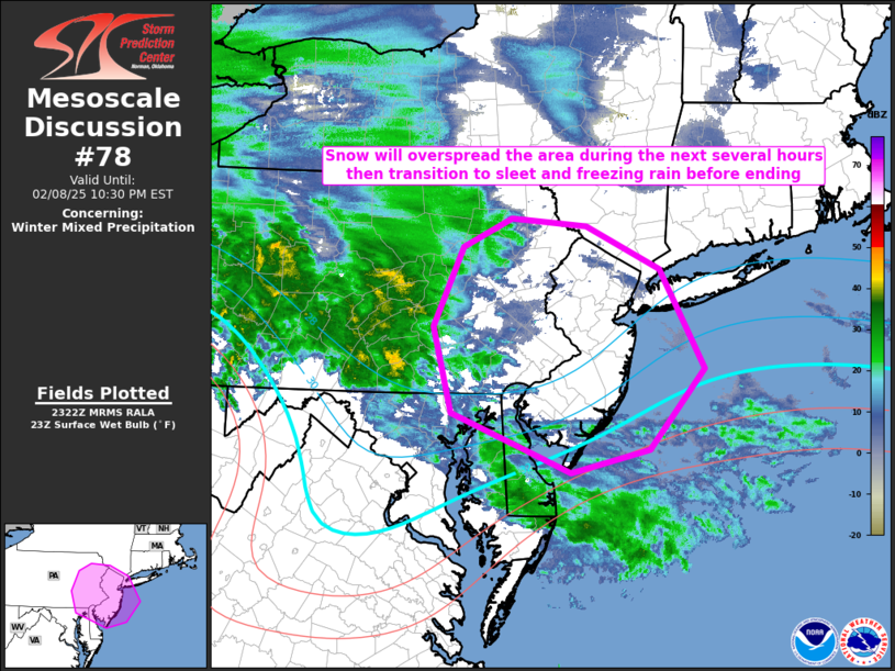
MD 0078 CONCERNING WINTER MIXED PRECIPITATION FOR FAR NORTHERN PORTIONS OF THE MID-ATLANTIC AND FAR SOUTHERN PORTIONS OF NEW ENGLAND
Mesoscale Discussion 0078
NWS Storm Prediction Center Norman OK
0524 PM CST Sat Feb 08 2025
Areas affected...far northern portions of the Mid-Atlantic and far
southern portions of New England
Concerning...Winter mixed precipitation
Valid 082324Z - 090330Z
SUMMARY...Snow should overspread the region in the next few hours.
With time, the snow should transition to sleet and even freezing
rain before ending later this evening/overnight.
DISCUSSION...An area of mixed winter precipitation continues across
western and central Pennsylvania this evening. This precipitation
area developed/is being maintained on the nose of strong low-level
warm-air advection across a deep layer. Over the next few hours this
warm-air advection and associated isentropic ascent will overspread
eastern Pennsylvania and much of New Jersey. Surface temperatures in
the upper-20Fs and low-30Fs, coupled with dewpoint temperatures in
the upper-teens and low-20Fs, yield wet-bulb temperatures below 32F.
Thermal profiles across the region will initially support all snow.
However, as the warm-air advection warms the low-levels, the maximum
temperature in the column should increase above 32F yielding sleet
and potentially eventually freezing rain before precipitation ends
from southwest to northeast.
..Marsh.. 02/08/2025
...Please see www.spc.noaa.gov for graphic product...
ATTN...WFO...OKX...PHI...BGM...CTP...LWX...
LAT...LON   39177553 39527647 40417671 41247631 41547565 41477463
            41017363 39987304 39137378 38907485 39177553