
WW 119 SEVERE TSTM IL MO 162020Z – 170200Z
URGENT – IMMEDIATE BROADCAST REQUESTED
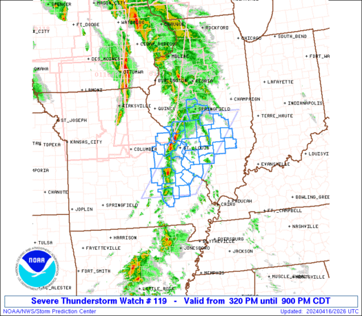
Severe Thunderstorm Watch Number 119
NWS Storm Prediction Center Norman OK
320 PM CDT Tue Apr 16 2024
The NWS Storm Prediction Center has issued a
* Severe Thunderstorm Watch for portions of
Southern Illinois
Southeast Missouri
* Effective this Tuesday afternoon and evening from 320 PM until
900 PM CDT.
* Primary threats include…
Scattered damaging wind gusts to 65 mph possible
Scattered large hail events to 1.5 inches in diameter possible
A tornado or two possible
SUMMARY…Strong to severe storms will continue to move
east-northeastward across the region this afternoon, with damaging
winds and hail as the primary risks.
The severe thunderstorm watch area is approximately along and 55
statute miles east and west of a line from 45 miles west northwest
of Mattoon IL to 40 miles southwest of Farmington MO. For a complete
depiction of the watch see the associated watch outline update
(WOUS64 KWNS WOU9).
PRECAUTIONARY/PREPAREDNESS ACTIONS…
REMEMBER…A Severe Thunderstorm Watch means conditions are
favorable for severe thunderstorms in and close to the watch area.
Persons in these areas should be on the lookout for threatening
weather conditions and listen for later statements and possible
warnings. Severe thunderstorms can and occasionally do produce
tornadoes.
&&
OTHER WATCH INFORMATION…CONTINUE…WW 116…WW 117…WW 118…
AVIATION…A few severe thunderstorms with hail surface and aloft to
1.5 inches. Extreme turbulence and surface wind gusts to 55 knots. A
few cumulonimbi with maximum tops to 500. Mean storm motion vector
24035.
…Guyer