
WW 321 SEVERE TSTM MD NC VA WV 262205Z – 270300Z
URGENT – IMMEDIATE BROADCAST REQUESTED
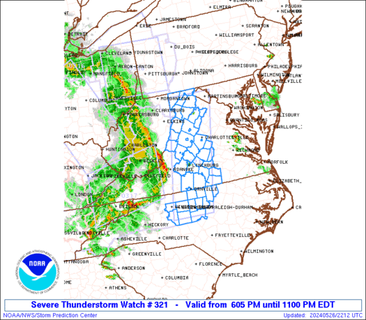
Severe Thunderstorm Watch Number 321
NWS Storm Prediction Center Norman OK
605 PM EDT Sun May 26 2024
The NWS Storm Prediction Center has issued a
* Severe Thunderstorm Watch for portions of
Far Western Maryland
North-Central North Carolina
Western and South-Central Virginia
Eastern West Virginia
* Effective this Sunday evening from 605 PM until 1100 PM EDT.
* Primary threats include…
Scattered damaging wind gusts to 70 mph possible
SUMMARY…An organized and long-lived squall line will likely
continue into the Watch area this evening across western Virginia
northward into far western Maryland. Strong to severe gusts ranging
from 50-70 mph will be capable of wind damage. Farther south, a
couple of strong to severe thunderstorm clusters will probably move
into north-central North Carolina during the evening and potentially
pose a risk for large hail and damaging gusts.
The severe thunderstorm watch area is approximately along and 45
statute miles east and west of a line from 35 miles west northwest
of Martinsburg WV to 40 miles southeast of Greensboro NC. For a
complete depiction of the watch see the associated watch outline
update (WOUS64 KWNS WOU1).
PRECAUTIONARY/PREPAREDNESS ACTIONS…
REMEMBER…A Severe Thunderstorm Watch means conditions are
favorable for severe thunderstorms in and close to the watch area.
Persons in these areas should be on the lookout for threatening
weather conditions and listen for later statements and possible
warnings. Severe thunderstorms can and occasionally do produce
tornadoes.
&&
OTHER WATCH INFORMATION…CONTINUE…WW 316…WW 317…WW
318…WW 319…WW 320…
AVIATION…A few severe thunderstorms with hail surface and aloft to
1.5 inches. Extreme turbulence and surface wind gusts to 60 knots. A
few cumulonimbi with maximum tops to 350. Mean storm motion vector
25035.
…Smith