
WW 441 SEVERE TSTM CO NM UT WY 211805Z – 220100Z
URGENT – IMMEDIATE BROADCAST REQUESTED
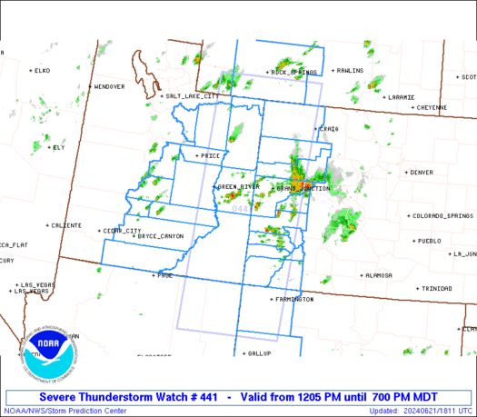
Severe Thunderstorm Watch Number 441
NWS Storm Prediction Center Norman OK
1205 PM MDT Fri Jun 21 2024
The NWS Storm Prediction Center has issued a
* Severe Thunderstorm Watch for portions of
Western Colorado
Northwest New Mexico
Central and Eastern Utah
Southwest Wyoming
* Effective this Friday afternoon and evening from 1205 PM until
700 PM MDT.
* Primary threats include…
Scattered large hail and isolated very large hail events to 2
inches in diameter possible
Scattered damaging wind gusts to 70 mph possible
SUMMARY…Scattered thunderstorms will form across the watch area
through the afternoon. The more intense cells will pose a risk of
large hail and damaging winds.
The severe thunderstorm watch area is approximately along and 75
statute miles east and west of a line from 80 miles north northeast
of Vernal UT to 85 miles southwest of Farmington NM. For a complete
depiction of the watch see the associated watch outline update
(WOUS64 KWNS WOU1).
PRECAUTIONARY/PREPAREDNESS ACTIONS…
REMEMBER…A Severe Thunderstorm Watch means conditions are
favorable for severe thunderstorms in and close to the watch area.
Persons in these areas should be on the lookout for threatening
weather conditions and listen for later statements and possible
warnings. Severe thunderstorms can and occasionally do produce
tornadoes.
&&
AVIATION…A few severe thunderstorms with hail surface and aloft to
2 inches. Extreme turbulence and surface wind gusts to 60 knots. A
few cumulonimbi with maximum tops to 500. Mean storm motion vector
25035.
…Hart